Showing posts sorted by relevance for query and mill road. Sort by date Show all posts

2019-09-11

Ayd Mill Road Reduction Money is Coming from the Dedicated Bicycle Fund

The Saint Paul City Council got a chance to ask questions about the mayor's proposed Public Works budget today and the topic of Ayd Mill Road came up.

What follows is Ward 3 Council Member Chris Tolbert's interchange with Director Kathy Lantry on the proposed changes to Ayd Mill Road, with some annotation by me.

Council Member Tolbert: I have a few questions. I think it might be good to have some sort of follow up. To be clear mill and overlay won’t happen this year as council directed and allocated, right?

Director Lantry: That is correct.

CM Tolbert: And there’s no mitigation strategies for Lexington or other roads, including the Lexington bike paths we just added and the other road diets stuff we did over the last 10 years to mitigate the traffic on that street, which includes 4 schools and a rec center on two blocks on it.

[It's worth pointing out that Lexington Parkway is a County road, and I am not sure what the point is here. Also, the term "mitigation" is strange. What are we mitigating? Speeding? "Traffic calming" is a better way of looking at this, especially if there are four schools and a rec center nearby. The concern is traffic speeding through residential streets? Funding for bumpouts, tightened curbs, maybe starting/finishing the bike boulevard, would be a way to shape that. We should prioritize reducing speeding through design features.] 

Director Lantry: I am going to check with my staff. The answer is not that we just assume the traffic is going to goo there, and we’re not going to do anything about it. Because I don’t think that’s the case I can certainly follow up with you about how we’re thinking bout those changes.

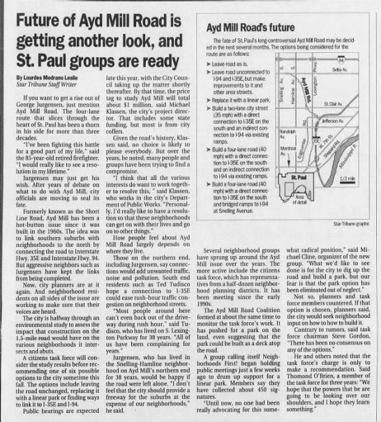
[The assumption seems to be that the two-lane Ayd Mill Road is not going to be able to handle 20,000 cars a day. It's worth noting that a two-lane road can handle significant traffic volumes. The West River Road peaks around 10,000 cars a day. This road should have good performance as it is grade separated and there are few intersections. Id' be interested in a traffic engineer prediction about this. I guess we'll find out. My best guess is that 15% goes to other regional routes, 15% goes to nearby arterials, 10% simply disappears, the rest of the cars stay on the two-lane road only going a bit slower but without any potholes.]

CM Tolbert: Can you tell us where the $5.2M comes from?

Director Lantry: Sure. The plan had $3.5M allocated to the mill and overlay of this road. Remember we’re making a one-way road into a two-way road. There are a ton of changes that have to happen there because of the on- and off-ramps. So the total estimated costs there are $5.2. So we have the $3.5M, and the additional $1.7M will be added to the street reconstruction bond sale this spring.

CM Tolbert: OK, is that coming from the bike path fund?

Director Lantry: For 2020 our recommendation for how you pay for the debt service on that additional $1.7, which finance tells me is $111K a year for 2020, is coming from the designated bike and ped fund. It uses $111K out of the $500K total.

[Um, this is not really a bike and ped project. It's a road reduction project, a climate action project, a traffic calming project, and long-term fiscal savings project. The bike and ped path is sort of a side effect of the larger policy decision about what this road should be and how the city should pay for it. It's a bit unfortunate that the $500K of dedicated bike funding is going, not to a regular bike plan project, but to clean up a problematic freeway. At least that's my view.] 

CM Tolbert: The administration made this decision and is there any plan to have this public process either with citizens or with the council on how to implement this, or whether or not this decision should be made?

Director Lantry: [Displaying wise incaution, because nobody nobody wants to have another task force or panel or committee or public meeting about this damnable project.] Ayd Mill Road is a street that has been studied for decades. That is not an overstatement. When we go out to the public to ask for feedback, and then you don’t intend to take it, it's is a waste of everyone’s time. The current city policy is to look at bike and ped infrastructure and ask if it fits into how we use our infrastructure. And so we’re happy to provide information about the timeline and items that we expect to do, but I want to be careful that if we have some public process and you’re looking for feedback and people say "don’t do it" and the intent is to go through with it, I don’t know that that’s the best way to go. Certainly we're hearing people’s opinions. We have a little briefing memo that we sent to some Council Members. We can send that briefing memo to adjacent district council asking if they have anyone from Public Works attend their meetings.

CM Tolbert: Ayd Mill Road needs to come back to this Council because we’re not part of this decision. The last decision we made was to Mill and Overlay it this year, and its not going to get done this year, which is a shame because its in terrible shape. [For the record, the "discussion" about the Ayd Mill Road mill and overlay was also done with almost zero notice or discussion. Public Works simply announced it, and there was a City Council hearing where almost nobody asked any questions. CM Noecker and CM Jalali Nelson were the only ones to meaningfully interrogate Director Lantry about it at all.] All the arguments we made last year, and its not going to get done this year.

The other thing is I appreciate your statement on public process I personally its important to me what my constituents think and I’m hearing a lot about it both for and against the proposal. And I suspect my colleagues are too. The budget thing last Wednesday, with one or two exceptions, we spent 90% of our time discussing Ayd Mill Road. Citizens are interested in what it has to say because this an important decision that will affect the neighborhoods and the arterial streets that are on there and hope it comes back to this council.

CM Prince: I did receive a really interesting idea from some constituent the idea was to do the mill and overlay on portion of AMR that’s the two-way street first, and then, because bike and ped improvements require different kids of treatments for on- and off- ramps, hold off on that part. But it would effectively be proceeding on the two-lane option and then seeing how that goes before you make a commitment to completing the bike and ped portion of that. I thought it was a way to handle it in the short term that might potentially save us some money. Wanted to put that out there. [Not a terrible suggestion but it also is not a money-saving one. The bike path is the cheapest part of this project. It's probably a zero-cost expense because you'd have been paving that part of the road regardless. The real expenses come from pouring new concrete to reconfigure the car traffic, and adding in all the signs and new signals needed.] 

CP Brendmoen: I'm hearing we would like to continue this conversation about this particular project we’ll work through Holly to get things set up to continue to have that. [More conversation about Ayd Mill Road. What fun!.]

[Watch the whole thing at the St Paul website; forward to 50:00 in to see the Ayd Mill Road discussion..]

UPDATE:

Here are the documents that Director Lantry mentioned in her spiel, the 2019 "briefing memo" and the 2009 Council resolution.


2019-09-16

Ayd Mill Road Comments from Dai Thao and Russ Stark

[CM Thao talking to the group riders.]
I had the pleasure of attending some of the Sierra Club's annual bike ride this weekend. The ride, done in partnership with the Midtown Greenway Coalition, the Saint Paul Bicycle Coalition, and other groups, was an exploration of some of the potential routes that might someday connect the Minneapolis Midtown Greenway into Saint Paul and all the way to Ayd Mill Road.

At the end of the ride, there were some speeches by notable elected or appointed officials , including the wonderful County Commissioner Trista MatasCastillo, Ward One Council Member Dai Thao, and Mayor Carter's Chief Resilience officer, (and former Council President) Russ Stark.

Both Thao and Stark gave speeches before the Sierra Club's bike-riding, greenway-loving crowd. Because they both mentioned Ayd Mill road in their speeches, I'm transcribing them for you here. If you're following the epic tragic hopeful saga that is Ayd Mill Road, I think you'll be interested in what they have to say.

First, Ward One Council Member Dai Thao:

[Note that the first part of Thao's speech was about riding bicycles in Minneapolis as a young boy. I did not transcribe it.]

Thank you for promoting health. As an Eagle Scout one of the important things for me is environmental justice. It's so easy for us to construct something man-made, but for our earth and our environment, it takes millions of years. To save our hills, our mountains, our landscape, our treescape, and so its important that we protect our environment.
And part of making sure we have equitable transportation is [that it's] a vehicle where you preserve our environment so that future generations, and our kids, and their kids, and their kids, can enjoy and they can look back, and its because of y’all coming together, taking responsibility, and working with office holders and policymakers to ensure that the future voices can be heard. I really appreciate you all doing this, and leading this effort.  
I want to thank Joshua for inviting me to speak today. 
And most of you probably want me to talk about Ayd Mill Road. And so, you know, look, so I was surprised when the Mayor announced that at the budget address because I wish I had known that in advance, and it wouldn’t be a surprise. And then, after that, I had meeting with Kathy Lantry, the Public Works director, and I asked here where the money’s going to be coming from? Are we going to cone it off? Are we going to model it? Just so there’s a process, right?  
Just like if somebody made a decision to not do the bike plan, or if somebody made a decision to take away a bike path, you all would want fairness. You all would want a process so that you could be at the table to see how its going to be implemented, and how its going to work out. And if there’s any mitigation that needs to be done, you would want to have money and resources to mitigate those issues.  
One of the hard and important things about being an elected official is that we get to hear from all sides of the story. I think that most people support the changes to Ayd Mill Road. But I think that, as government, we need to be transparent. We can’t just tell people what to do. We can’t just tell them that this is the right thing to do. 
One of the examples that we did, the organized trash, there are several things we could have done to save all that [from becoming a] fiasco. That is, maybe implement it, to do one ward at a time, so we could fix all the glitches.  
I’m saying this as being in the IT industry for 20 years, and when we do data migration or update from Windows 2000 to Windows 365, we don’t migrate the data all at once. We don’t do all the migration, we do department by department, and we fix those and then we implement them organization wide.  
Just with these thoughts, I look forward to having this conversation with you, and we’re going to do, we’re going to make Ayd Mill Road work for everyone. And we all need to be at the table, and lets make this work for everybody, and I look forward to making this work for the road ahead.  
Thank you so much.

After CM Thao, Russ Stark from the Mayor's Office took the microphone:

With regard to bike infrastructure, we are really excited about the greenway. I've personally been involved in that idea for almost 20 years now. I’m really excited that the Sierra Club and the Greenway Coalition and others are keeping the dream alive on this. It's really great work. there’s a really good opportunity for us to create a wonderful piece of infrastructure. It’s a long way forward and its not going to be easy, but I’m really looking forward to doing that together. 
With regard to what we’re doing here in Saint Paul, there a few things to comment on. Mayor Carter created our city’s first ever, with the council’s support, ongoing funding for bikeways in the city. Its five hundred thousand dollars, and it's the first year we’ve had that funding in place. It's a really good start, but we have more work to do.  
Number two, thanks to a change in state law, we are working with our partners both here and across the river in Minneapolis to look at opportunities to lower speed limits on city streets. This is something that a lot of us have been wanting to do for a long time. It is one of a series of things we’re going to have to do to to make our streets safer for everyone. It's one of the key things we need to do. 
Number three, the Ayd Mill Road proposal. This proposal is literally 20 years in the making, in many ways. Some of you may not know that 21 years ago the city of Saint Paul created a task force of community folks to look at the Ayd Mill Road corridor. That actually ended up recommending tearing the thing out and putting in a park.  
We never found the resources to do that, and it was not supported by mayors back then. And this idea of a two-lane roadway was identified by the Council back then, and then reiterated by two young council members, Melvin Carter and Russ Stark, back in 2009 as the preferred plan with a bikeway.  
Ayd Mill Road is the most studied road in the history of Saint Paul. There is nothing more to study. We know exactly what will happen when we make changes to the roadway. Some of our suburban neighbors will choose a different route to get from the suburbs to downtown Minneapolis. That’s what will happen. The rest of us who actually have to make local trips here in Saint Paul will continue to do what we’re doing, and the road will still be able to carry lots of cars. 
It will just also carry tons of bikes and people, and that’s really the idea. Thank you all for doing what you’re doing. Again, the mayor sends his regrets. He appreciates everything that you’re doing, and have a great rest of your weekend here. 

There you go!

Make of it what you will, and feel free to post comments or reactions here. I would currently put the odds of this road project happening at 4:1 in favor, though there are still plenty of things that could change that, including a big City Council election in November.

2020-03-20

Still Further Thoughts on Ayd Mill Road

[Ayd Mill drone shot!]
It might seem incongruous to write about Ayd Mill Road in these trying times, but now more than ever, this road continues to be a thorn in the side of the city of Saint Paul. The public meeting, the existence of which was an outcome of the heated conversation at City Council three weeks ago, was supposed to take place this week. In its place, we have a 30-minute youtube video from Public Works explaining a few things.

The point here, though, is that this moment of social distancing and quarantine is the PERFECT TIME to send in a thoughtful comment in support of progressive low-car / no-car changes to Ayd Mill Road. So take some time out of your humdrum working-from-home schedule, brush your cat off your keyboard, and comment today!

Obviously a lot has happened since I last wrote about this concrete quagmire, and how Saint Paul “fixes” this road has rightly faded into the background. But the road must go on, and public works is still going to spend its allocated budget this year on maintenance and construction. So I wanted to post an update with some of the new information I've learned since I last wrote about Ayd Mill Road.

But first, let's watch this informational video!


OK well. Here are my quick takaeaways from the presentation and survey:
  • It is very nice that "repaving the status quo", i.e. the initial Public Works / current CM Thao proposal, is not one of the options mentioned in the video. Indeed, it is not mentioned at all. 
  • The "timeline" of Ayd Mill Road really glosses over former Mayor Randy Kelly’s highly-controversial "test connection" back in 2003, which is a key reason we're in this mess today.
  • Wow those renderings are cheesy!
  • Why does the 3-lane option require fewer drainage improvements than the two-lane option? Inquiring minds want to know. I'd imagine the drainage issues would be the same, regardless.
  • What is the reason for the claim that the Jefferson ramp is a minor adjustment for one, but not the other? 
  • They talk about reconstruction as a cost driver, but don't mention the reason, which is the the turn lanes. I wonder what the range of possible stacking length for the turn lanes was, and how that might have affected costs for the two-lane option.
  • What is the design speed of the new road going to be? And what will be the posted speed of the new road? That seems super important because...
  • The video glosses over the safety issues. Decreasing speed should be a major goal of this project. And yet the focus here is  “separating” cars going each direction with a median? That's a key design feature if you have a high-speed road (>40mph, like it is now), but if you are designing a low-speed road (<30mph a="" bikes="" boulevard="" buffer="" case="" design="" don="" especially="" have="" if="" important="" in="" is="" li="" like="" lower="" median.="" mississippi="" nbsp="" nearby.="" need="" or="" pedestrians="" river="" safer.="" speed="" t="" than="" that="" the="" this="" two-lane="" with="" you="">
  • A quote here from the second presenter: “It stands to reason that the three-lane operates more efficiently than the two-lane.” ...hm, does it? I don't see why that would necessarily be true. If you create more crashes with a three-lane road due to weaving traffic and contrasting speeds, it is less efficient and less safe.
  • Finally, I hate to say this, but the survey is terrible. I've never seen a worse one from anyone other than a hack PR firm. 
So, yeah. Well at least this video and survey is still better than an in-person meeting about Ayd Mill Road would have been. I can only imagine how terrible that experience would be. The focus groups alone would have set a new state record for mansplaining.

The Big Picture on Ayd Mill Road

Since I last wrote about Ayd Mill Road, and expressed my opinion that the best option for the City of Saint Paul would be to remove it completely from the city-funded motor vehicle network, I've had a few in-depth conversations with folks close to the project, both within advocacy groups and within City Hall.

While my mind hasn't really changed, and I stand by most everything that I have previously written about this project, I do want to share a few things I've learned. Here are a few things that I've learned.

First, the concrete roadbed underneath the degrading is in better shape than people (and myself) had thought. That means that a mill and overlay will theoretically last longer than one might have initially expected (maybe 15-20 years instead of 7-10).

The caveat is that there’s a particular spot near Grand Avenue where there’s a natural spring (that presumably once fed Ayd Mill Creek). There, the city needs to do something -- re-grading, or installing a new drain -- that will cost at leastr  $1M. I'd imagine that, in any roadbed re-paving scenario, including re-paving the status quo, that would would have to happen to keep the project from quickly degrading.

That said, I imagine that with a theoretical park/trail-only option, this cost could be avoided. Or maybe, the money could be spent instead on rainwater or daylighting.)

Second, the main cost driver of the two-lane road option is installing turn lanes, which would require pouring new concrete to create enough stacking capacity to allow people to wait for the light before exiting.

(More on this in a moment.)

#3. Finally, the city’s process has been admittedly flawed, with some missed opportunities to communicate and/or come up with consistent options over the last year or so. It’s understandable, as Public Works projects are constantly evolving and often the timelines are improvised depending on what money and resources are available.

But, that said, the current proposal is better than a lot of other outcomes.

Ranking The Options

Speaking of which, here’s my ranking of the options that are currently on the table…

  • #4. The $4m four-lane status quo repaving — as I’ve said, this sucks.
  • #3. Doing nothing — Honestly, this could be great or terrible, depending on what ends up happening. If the city “kicked the can” once more and didn’t repave it this fall, likely the road would have to be shut down over the winter. At the very least, though, that would give people a chance to think through the situation more completely, as well as demonstrate what traffic impacts might look like.
  • #2. The $9m 2-lane option — this is the best outcome, but it’s just costs too much money. For example, $9m could get you a long way toward completing the Capital City Bikeway, which would have many times the benefits of the Ayd Mill Road connection for bicyclists and for the city's economy.
  • #1. The $7m 3-lane option — Well, it’s a compromise, and at least it’s a change that would finally eliminate any freeway-connection pipe dreams. That said, I find it hard to believe that the bike lane would be very pleasant or useful in the short term, but it's better than nothing.
But, I still feel that there are two options that are not on the table, and that’s frustrating. Here's one...
  • #?. Closing the road, building a recreational trail and fundraising for a park —  I’ve already written about this, as have others. If you ballpark $2m for the trail, this would truly be the best choice, but sadly many people in Saint Paul are yet not ready to create a future with fewer cars on the city streets.
And there's this, lingering around in my head...
  • #?. A cheaper 2-lane option, somewhere in the existing $7m range — I still think, stubbornly, that there should be a way to design a two-lane road that falls close to the consensus budgetary range for this project.

[The St. Clair intersection is pretty useless.]
One way to do this might be to eliminate one of the access points. The obvious choice here would be the St. Clair on- and off-ramps. For one thing, this entire road offers only marginal benefits to the transportation network, but that’s especially true for the St. Clair intersection, where they’re less than a mile (and a 2-minute drive) away from the nearest 35E on-ramps and even closer to the Jefferson ramp. Simply closing this intersection has to shave a million bucks off the project cost.

I’d also be really curious about pricing out intersection alternatives, like a roundabout. In theory, it could save money on traffic signals, decrease speeds, and reduce the need for any turn lanes.

Conclusions

In short, I wish the City could have done more to come up with a more affordable, less compromised plan. I’m sure the consultant did their best with a very limited budget and the set of scope parameters they were given, but there have to be more design choices out there that could provide a quality recreational trail at a reasonable price tag.

This is to say that I reluctantly support the existing compromise, but the takeaway for me is that it’s a shame that we can’t make better decisions with city money and on city-controlled projects. Saint Paul is hampered right now by its lack of resources, both being short on critical staff in Planning and Public Works, and with a lack of tax base and revenue more generally. With a project of this size and budget, with such long-term implications, and with so many ambitions and idealistic plans on the city's books, this three-lane compromise project, while better than the status quo, seems like a missed opportunity. If we really want to make meaningful changes to our city, we need to do better.

So, go forth and take the "survey". At the very least, when this passes, I'll never have to write about Ayd Mill Road again!

2019-08-20

Open Letter to the Saint Paul City Council about Ayd Mill Road

[Rendering of one possible design for Ayd Mill Road, from the Saint Paul Bicycle Coalition.]

As someone who grew up next to Ayd Mill Road, and have been using it my entire life, I was thrilled to hear that Mayor Carter and the city’s Public Works Department are going to commit to reduce and reconfigure Ayd Mill Road when they repave it this year. I believe this decision reinforces and reaffirms many of the city’s values, puts Saint Paul in a better place fiscally, and will not create major traffic problems on Saint Paul’s streets.

For those reasons, I think you should support this decision.

First, a key criteria for deciding the future of Ayd Mill Road has to be costs versus benefits. Ayd Mill Road is a 100% city-owned street, and city taxpayers are on the hook for any long-term maintenance of this infrastructure. This makes it very different than other freeways or major traffic arterials, and for a sixty-year-old road with deteriorating surface conditions, we should think carefully about how best to spend precious city dollars.

As you know, the long-term maintenance picture for Saint Paul streets is a bleak one, and when opportunities arise to downsize overbuilt streets and roads, we should seize that chance. This unique street, a four-lane divided roadway that connects with walkable city streets on one end and a freeway on the other, is a the most obvious of these kinds of projects. Reducing the road’s footprint will save the city millions of dollars in both the long- and short-terms.

Second, I believe the traffic impacts will be minimal. A grade-separated two-lane road with few intersections can actually handle a lot of daily traffic, and in cases like these, reducing lanes affects speed more than overall volume. The problem with Ayd Mill Road has always been its intersections with the regular street grid, rather than any congestion problems on the road itself. I would encourage you to keep an open mind about how this transition might work out well for all parties involved.

Finally, this decision reflects our shared values, especially those in the draft Climate Action Plan. Facing the existential problem of climate change, the Climate Action Plan lays out the ambitious goal of reducing city vehicle miles traveled by 2.5% each year. If we hope to achieve meaningful action on climate change, reducing and reprioritizing space given to roadways is an absolutely necessary step. 

Ayd Mill Road is a decades-long saga, the kind of “third rail” that few political leaders want to address. Debates over the road began in the 1940s and continued vehemently throughout many lifetimes of political leaders, neighbors, and advocates. In 2002, the decision to “connect” the road to 35E was done as a “test” by then-Mayor Kelley with very little public input. On the other hand, the most recent Council action was the 2009 vote to adopt the current proposed configuration.

This is to say that Mayor Carter’s bold action on Ayd Mill Road reflects a long-process of deliberation and indecision over the future of this valley. I am thrilled that, at long last, the City of Saint Paul will be taking steps to transform this polluting liability into a public space that reflects and amplifies our shared values.

Please support this process as it moves forward this fall.

Thanks,
Bill Lindeke
Chair, Transportation Committee of the Planning Commission

2019-03-25

The Eternal Return of Ayd Mill Road: an Illustrated Timeline


[Cars drive back and forth to Dakota County over the potholes in the AMR trench in 2019.]
Here are some highlights from the Minneapolis Star Tribune newspaper archive about Ayd Mill Road (AMR), Saint Paul's great mid-century sunk cost albatross... 

Mid-1940s to mid-1950s: Freeway route is planned


According to a 1981 article [below]: "it's been 50 to 60 years since St. Paul identified the Pleasant Avenue corridor as a potential major roadway... the Minnesota Department of Highways conducted a public hearing, and the city and federal government included the corridor in the interstate system in 1957.."

AMR was not technically part of the system, but a road was planned there regardless. As of 1953, it is a valley containing a well-used railroad line, the "short line" between the two downtowns.


1962: It begins...


The road is built in the valley. "This is not a highway to nowhere," someone says.

It is intended to connect the industrial midway area to the planned 35E freeway, which, unfortunately for AMR, will not be built for twenty years. Cost is $8.3M in today's dollars. My best guess is that the road is intended to be used by trucks for industrial purposes.

Then the road sits in the valley for twenty years, rarely used.


1981: 35E Finally Constructed as a "Parkway"; AMR is an Added Bonus


After two decades of neighborhood debate, lawsuits, protests, pressure from suburban and business interests, 35E is finally allowed to be constructed, provided there are no trucks and that the speed limit is restricted to 45 mph. The 35E freeway costs the state at least $200M in local funds, but the remaining expense (4/5ths) is paid for by Federal dollars.

Partially completing the on-ramps to AMR is included in this cost.

Article states:
"[Met Council] staff recommended that a direct link between the parkway [and the downtown interstate system] be provided, as well as a link to the Short Line Road [former name of AMR]. That link would not be opened to traffic until the city could upgrade Short Line."

Special note: The article includes quote from State Senator Marilyn Lantry, mother of current Saint Paul Public Works Director and former Council Member Kathy Lantry. That means Director Lantry is the second generation of her family to wrestle with what to do, and how to pay for, Ayd Mill Road quasi-freeway.

Also: Then late-Senate Majority leader Nick Coleman is also mentioned in the article, the father of the former mayor Chris Coleman, meaning his family also had two generations of dealing / not-dealing with AMR.


1987: Road Still "Goes Nowhere", Name is Changed


In 1987, Minneapolis columnist Doug Grow writes a snarky definitive history of the road.

Article states:
Even now, St. Paul engineers are said to be muddling over charts and maps, doing a study on the feasibility of making the road that goes nowhere, go somewhere. Maybe start somewhere, too.... 
But some things are best left with an air of mystery about them. The Short Line is one of those things... Wanderlust is basic to the human condition... The problem is most of us never can find the time to take a trip that has no predetermined destination. 
That's where the Short Line comes in handy. It will take you nowhere. But it will do it quickly... [but] be careful of both chuckholes and speed traps. 
Don Nygaard, director of public works in St. Paul, sees neither much humor nor much mysticism in the Short Line. "Without digging through the records," Nygaard said, "I really couldn't tell you what its purpose was." 

Shortly thereafter, a sign is erected renaming the road, and the "Short Line Road" becomes "Ayd Mill Road."


1988: Task Force #1


The first AMR "task force" meets, convened by the Planning Commission. Options include tearing up the road, restricting traffic or allowing only one-way traffic or car pools, leaving it as is, and connecting it to the freeways on either end.


1992: A temporary car-pool connection is floated...


Because a bridge on the other side of downtown is out,  Saint Paul Public Works' "traffic planners", with nudging from transit planners (!), floated the idea of opening AMR to 35E to "relieve congestion", only allowing car pools "during peak hours."  There was a public meeting.

Quotes from the piece:
AMR now carries about 11,000 cars a day. The temporary link would increase the traffic by 1,000 or 2,000 more vehicles during peak hours. 
"The people should not have concerns that there is a hidden agenda for addressing the Ayd Mill Rod. problem for the future. Rather, it is a short-term connection for the summer's congestion problems,' City Council Member Bob Long said. 
There is little chance that AMR would ever become the link between I-35E and I094 that once was envisioned. To permanently connect the two interstates would require an environmental impact study and upgrading AMR to freeway standards.

I do not think this car pool connection actually took place...


1998: Task Force #2


Twenty-one years ago, people are already tired of talking about AMR. Options are again laid on the table, including leaving it alone, making "improvements" to it without connecting it, getting rid of it in favor of a park, re-building it as a two-lane street with a direct south connection, building a four-lane road with a direct southern connection but no northern connection, and connecting both ends as a four-lane highway.

Quote from the article:

The city is halfway through an environmental study to assess the impact that construction would have... A citizens task force will consider the study results... 
The AMR Coalition formed at about the same time to monitor the task force's work. It has pushed for a park on the land, even suggesting that the park could be built as a deck atop the road.... 
What we'd like to see done is for the city to dig up the road and build a park, but our fear is that the park option has been eliminated out of neglect." ...
Said O'Brien, a member of the task force for three years: "I hope that the powers that be are going to be looking over our shoulders, and I hope they learn something." 

The price tag for the study is $1.5M in today's dollars


1999: Planning Commission Wants a Freeway Connection


The Planning Commission votes to connect the road to 35E, while  task force votes to make it a park.

Quote from the article:
By connecting the road directly to the freeways, Gordon noted," you'd be taking about 10,000 cars a day that now use Ayd Mill and you'd be pulling them off city streets" at either end. 
The citizens task force, using a weighted formula, in August voted on six proposals for Ayd Mill. The park got the most votes with 47; the roadway alternative chosen Friday received the fewest votes, 28.


Article estimates costs for the connection as $55M, and the cost of building a park at $14.4M (both in today's dollars).


2000: City Council Votes to Connect Road with Two Lanes


The City Council votes to have a two-lane road connection, "splitting the difference" between the Planning Commission and task force plans. Then-CMs Kathy Lantry and Jay Benanav dissented, arguing that a connection would just shift traffic problems into other parts of the city.

Costs estimated to be "at least" $49M in today's dollars.


2002: Mayor Kelly Connects AMR to 35E with Four Lanes


Mayor Randy Kelly conducts a year-long "test" of a southern connection with four lanes, without doing an environmental review of the project. A District judge refused to grant a restraining order to stop the connection.

From the article:

"The council two years ago approved a two-lane connection plan, but the project was never begun for lack of funding. 
No protestors were seen along the 1.5-mile stretch of AMR Wednesday, but Flaherty said police had received reports of possible acts of civil disobedience to come. 
"The police are prepared and will not allow people to break the law or obstruct the road," Flaherty said. "Most of the neighbors are good taxpaying citizens, but there are professional protesters who will take any case and this is as good as any."

Cost for the "test" is estimated as $700,000 in today's dollars.

P.S. This also happened.


2003: "Test" Stays in Place


After the "test", there was a public meeting. Some quotes from the article:
"One neighborhood has benefited while another neighborhood has suffered,” [a concerned neighbor] said. Meanwhile, he added, traffic overall will inevitably grow. 
[Then-Mayor] Kelly will hold a public hearing Thursday at a school in the Highland Park area to present data from the yearlong test conducted by the city on the Ayd Mill corridor’s air, noise and congestion.  
Traffic counts down Kelly aide Howard Orenstein said the results show that traffic counts went down at most locations after the connection was made, except for Ayd Mill Road itself and the Hamline Avenue exit. There were significant traffic drops on Lexington Parkway and Jefferson and Randolph avenues.  
But [activist] Ludemann, City Council Member Jay Benanav and other connection opponents say the test proves that hooking up Ayd Mill to the freeway was a bad idea. 
Overall trends shown by the data disguise noise and pollution increases at some recording locations, they said. Benanav said that even though air quality remains within state standards, it’s still higher at Hamline and Ayd Mill than at the congested intersection of Snelling and University avenues. He wants to return Ayd Mill to a two-lane road with no freeway connection. “A few years from now Lexington will find it’s as busy as before because traffic expands to fill the gaps, and that’s what will happen,” Benanav said. 
“You’re bringing more cars, more noise, more pollution into the most livable urban core in the country,” he said. Orenstein said traffic would increase in the area whether Ayd Mill Road is attached to the freeway or not. He said Kelly is leaving open all of his options, including a possible connection of Ayd Mill at the north end to I-94 — a project that would cost millions of dollars and require completion of the environmental impact statement begun years ago.
The four-lane connected road was left in place.


2009: The City Council Votes for a Two-lane AMR with a Bike Trail, Task Force #3 Begins 

The City Council weighs in again on AMR:
Council members also approved a resolution to "clarify the current and future status" of AMR.... 
Wednesday's council action called for a new community process to discuss the future of the road, which the City Council wants to be two lanes with a bicycle and pedestrian trail.

The bike connection never happened, thanks to a lawsuit from a railroad company.


2013: Task Force #4?


By now the well-used road is an "ugly chipped-concrete bypass" [that] "spills traffic onto Selby Avenue.

From the article:
A community task force is asking the city for a $150K study [$162K in today's dollars] to analyze the issue and propose a makeover in keeping with their concerns.... The AMR she envisions would be something akin to a 35-mph landscaped parkway, with room for pedestrians and cyclists, that would end not at Selby but curl northward on a new route through an industrial area to hook up with Interstate 94. 
In 2005, and environmental impact statement analyzed Kelly's proposal to turn AMR into a parkway and extend it one-third mile to the north to connect with I-94 at st. Anthony Avenue. But the project, estimate to cost $44M [$56M in today's dollars], was overshadowed by work on the Central Corridor and shelved.


2018: 5-Year Plan Proposes Spending $3.2M to Mill and Overlay AMR


With the fifty-five-year-old road close to un-driveable without major maintenance, the Public Works Department proposes a mill and overlay, typically a short-term fix.

Prediction: that $3.2M will be more expensive in 2023 dollars.


[See also the Ayd Mill Road community timeline, from a Saint Paul neighborhood group.]

2013-02-13

Reading the Highland Villager Op-Ed Extra #5

[The ugly and dangerous 4-lane status quo of Hamline Avenue.]
Final design for Hamline Avenue is a bridge too far

By Paul Busch and Mike Madden

Neighborhoods First! would like to thank St. Paul Mayor Chris Coleman and the St Paul Department of Public Works for the recent series of public meetings held at the Western District Police Station regarding the design of the proposed Hamline Avenue bridge over Ayd Mill Road and the Canadian Pacific railroad tracks. City bridge engineer Glenn Pagel, in particular has been informative and responsive to inquiries from neighborhood residents about the new bridge.

Unfortuantely, we are unable to support the final design of the the bridge. It is our view that four traffic lanes are excessive to accommodate the current traffic volume of approximately 16,000 vehicles per day on Hamline Avenue. We believe that a three-lane configuration would not only be adequate, it would be safer.

When the similar north-south arterial streets of Fairview Avenue and Lexington Parkway were converted from four lanes to three a few years ago, the purported threshold of traffic volume for those conversations was no more than 18,000 vehicles per day. Indeed, the Federal Highway Administration suggests that three-lane conversions can be considered for roads of up to 20,000 vehicles per day.

We recommend that the entire stretch of Hamline from Summit to University avenues be restriped as a three-lane road, with the resulting surplus right-of-way converted to bike lanes. This would benefit both bicyclists and pedestrians en route to and from the Central Corridor's Green Line after it begins operating next year. The bike lanes would provide a buffer between motor traffic and pedestrians, making the sidewalks safer and more inviting to use.

We also believe that the width of the proposed replacement bridge at 68 feet, 10 inches, is excessive, and thus more expensive to build that it needs to be. If it were constructed with three 11-foot motor vehicle lanes, two 5-foot bike lanes, and two 8-foot sidewalks, it would accommodate all three modes of travel at a width slightly less than the existing bridge's 60 feet, 6 inches, Significant money would be saved on the construction of the span itself, and the work that is needed on the existing bridge abutments would be minimized.

While we are gratified to learn that the placement of the bridge's piers will accommodate any future alternative uses of Ayd Mill Road, the explicit linkage of the bridge's functional design to the final disposition of Ayd Mill Road is troubling to us.

Those who were in attendance at the December 12 public meeting were told that if and when Ayd Mill Road is extended to I-94, the Hamline bridge could be reprogrammed with sidewalks and bike lanes widened to 10 feet and 8 feet, respectively. However, this is just a further overexpenditure of taxpayer money and an attempt to link the Hamline bridge to Ayd Mill Road. Those two projects should be separate and distinct.

Finally, we ask that Ayd Mill Road be restriped with a single lane in each direction, that its speed limit be reduced to 30 mph, and that bicycles be safely reintroduced to that roadway to coincide with the construction of the Hamline bridge. Such a configuration is consistent with the preferred alternative for Ayd Mill Road that the City Council has identified: a two-lane configuration extended north to St. Anthony Avenue.

Adopting all of these recommendations would bring a measure of relief to the residents living near the north end of Ayd Mill Road who have endured the hardships and hazards brought about by the premature opening of the south ramps to and from I-35E in 2002.

2014-01-16

Reading the Highland Villager Op-Ed Extra #5

The Vintage: Paving the way to Ayd Mill Park

by Mike Madden

Neighborhoods First appreciates the attention that the Vintage/Whole Foods Market project has brought to the congested traffic conditions at the intersection of Selby and Snelling avenues and the unfinished business of Ayd Mill Road. yet, of the six potions that have been considered for reconstructing or replacing Ayd Mill Road, it is the linear park that best complements The Vintage and delivers the greatest benefit to the people of St. Paul.

With the adoption of the Central corridor Development Strategy in 2007, it seemed the city of St. Paul had turned a corner in understanding the relationship between transportation and land use and the need to reduce reliance on the automobile as a strategy for growth and environmental protection. The transportation infrastruucture supporting The Vintage, nominally a transit-oriented development, is almost entirely automobile-oriented, with the proposed $50 million extension of Ayd Mill Road as Exhibit A.

The St. Paul Department of Public Works has also recommended converting a portion of the Selby Avenue sidewalk to a right-turn lane and extending the left-turn lane on southbound Snelling Avenue north to Dayton Avenue. This is the sort of 1950s transportation planning that hollowed out our cities. It beckons automobiles and discourages walking, biking, and transit use.

At one-fifth the cost, replacing Ayd Mill Road with a linear park would deliver the same relief from traffic congestion on Selby as would connecting Ayd Mill Road to I-94. The linear park also provides green space and reduces emissions.

There are several transit plans on the table that would complement The Vintage. Snelling Avenue bus rapid transit is one. The Central Corridor EIS also envisioned new bus routes on Fairview and Hamline avenues. Together with a Route 21 that no longer detours to Midway Center, these transit improvements would move us closer to a transit grid.

A Canadian Pacific Rail alingment of commuter rail thorugh Merriam Park is a project found in the region's 2020 Transitway Plan. It would connect the Red Rock and North Star commuter rail lines, and with its proposed station at Snelling and Marshall, it would be of obvious benefit to The Vintage and to the people of St. Paul

Neighborhoods First commends Ryan Companies and Whole Foods for providing ample and protected bicycle parking, but once again we see that a good redevelopment project is not being supported with the proper infrastructure. Snelling Avenue is not bikeable, and Selby is not much better.

The extension of the Midtown Greenway bike trail is widely recognized as the most important piece of bicycle infrastructure yet to be built in St. Paul. It would run along the northern edge of the Snelling-Selby development. The city of St. Paul's past efforts to negotiate with CP Rail for biek trail right-of-way have been thwarted; however, with the help of the federal givernment, this project could be realized.

A four-lane extension of Ayd Mill Road to the I-94 frontage roads would do more harm than good. It would take land from Concordia Universituy and displace several businesses, costing St. Paul jobs and tax revenue and offering little if any opportunity for redevelopment. It would result in measuable increases in traffic on St. Clair, Grand and Marshall avenues, and a 130 percent increase in traffic on the residential portion of Concordia Avenue. It would remove the Pascal Street bridge over I-94, and among the alternatives for Ayd Mill Roa,d it would result in the highest level of emissions.

Neighborhoods First recognizes that the linear park would result in traffic increases on Lexington Parkway. That is regrettable. But as we debate the best use for the Ayd Mill Road corridor, let's understand the pros and cons of every alterantive and bear in mind that we can't build our way out of congestion.

Mike Madden, a resident of Merriam Park, is a co-founder of the local advocacy group Neighborhoods First.

2015-01-08

Reading the Highland Villager *Breaking News* #1

[Note: When hugely important stories for the entire city of Saint Paul break in a local newspaper that's not online and is only delivered to wealthy areas of the city, it illustrates precisely my points about how information is power. I also think that the Villager is exaggerating the issue here, maybe to the point of misleading people. "When Homans says "a connect", what exactly does she mean?]


Plan for finally connecting Ayd Mill Road to I-94 is in the offing
By Jane McClure

What to do with the north end of Ayd Mill Road is a decades-old conundrum that may finally be addressed in the new year. Money for further traffic studies, let alone road construction, will not be sought through the city of St. Paul's 2016-2017 Capital Improvement Budget (CIB) However city officials say they are nearing a decision on a north-end connection.

While that is not likely to win favor among those who have wanted to remove Ayd Mill Road and replace it with a 1.6-mile-long park, it may eventually bring relief to Snelling-Hamline residents who have tired of traffic tie-ups on Selby and Hamline avenues and cut-through traffic on adjacent side streets.

"I think the issue is not whether there will be a connect, but how the connection will be configured and how many traffic lanes it will have," said Nancy Homans, public policy director for Mayor Chris  Coleman and acting director of the city's Department of Public Works.

According to Homans, there will never be total agreement about what to do with Ayd Mil Road's north end. Nevertheless, city officials will announce the next steps to be taken sometime this year following discussions among Coleman and City Council members Dai Thao, Dave Thune, Russ Stark and Chris Tolbert, whose Wards 1 through 4 are all on or near Ayd Mill Road.

[...filler mostly some history and a story about a guy who lived on Selby but then moved away...]

According to Homans, Public Works staff do not see a need for extensive studies of Ayd Mill Road's north end. The most recent environmental impact statement (EIS) for the roadway was completed in 2005. In 2009, the City council passed a resolution stating that Ayd Mill Road should remain a city street and that a supplemental EIS should be undertaken to consider the pros and cons of reducing the roadway to two traffic lanes and extending it north to the I-94 frontage roads of Concordia and St. Anthony avenues.

[For more on Ayd Mill Road, see Then & Now: Ayd Mill Road, Podcast #56: Ayd Mill Road 101 with Mike Madden, Imagine an Ayd Mill Linear Park, and Three Half-Assed Freeways that Nobody Will Miss.]

[The article.]

Timeline of Ayd Mill Road Community and City Decisions

[This was put together and forwarded to me by community members in the Ayd Mill Road area. It is accurate as far as I know. See contact info at the bottom of the page.]


-->
Ayd Mill Road Timeline

YEAR
ACTOR
ACTION/QUOTE
1999
City of St. Paul
Draft EIS Completed
1999
Community Councils
Community organizations select their preferred alternatives through extensive community process.  City Sponsored Ayd Mill Road Task Force selects Linear Park.  Merriam Park selects no-build, Snell-Ham selects linear park, Lex-Ham selects linear park
April 12, 2000
City Council Resolution 00-347
Resolved that St. Paul City Council hereby selects the two-lane extended option as the preferred alternative for the Ayd Mill Road Environmental Impact Statement.  Signed by Mayor Norm Coleman.
June 2002
Mayor Randy Kelly
Ayd Mill road south ramps opened for “test”.  Test is in violation of MN Statue 116D.04 Subd. 2b. that forbids the starting of a project until the EIS has been determined adequate; and violates EQB Rule 4410.3100 that the government unit shall not take action that will prejudice the ultimate decision on the project until the Final EIS has been determined adequate.
2002-2005
Mayor Randy Kelly
City works on Final EIS, studying the 4-lane connection in violation of the stated purpose of the Final EIS “The purpose of the final EIS is to document and evaluate the preferred alternative”(from title page of Final EIS)
2004
Merriam Park
Adopts Community Plan that includes recommendation of a no-build
2005
MNDoT/FHWA
Final EIS studying the 4-lane connection completed
Summer 2005
Councilmember and Mayoral Candidate Chris Coleman
“As you know my position on Ayd Mill Road is clear.  I support the compromise two-lane parkway plan passed by the City Council on April 12, 2000…”Just to be clear I do not support a four-lane highway or Mayor Kelly’s proposed $45 million connection to I-94 on the north end of Ayd Mill Road.”… “The only way we are going to stop Mayor Kelly from shoving a four-lane highway and $45 million connection to I-94 down our throats is if we beat him in November.”
2006
Snell-Ham
Adopts Community Plan that includes Linear Park as their preferred alternative
September 02, 2009
City Council Resolution 09-878
Resolved, that the St. Paul City Council calls on the Mayor, the Department of Public Works, and the Department of Planning and Economic Development to initiate a community process around the future of Ayd Mill Road.  This process shall include a Supplemental EIS process to examine the effects of reducing the existing roadway to two lanes and the effect of a possible two-lane northern connection of St. Anthony Avenue
December 8, 2009
Union Park Community Council
The UPDC calls for a thorough and on-going process that requires that the conduct of the S-EIS be open and transparent to the public and citizen participation take the form of a reconvened Ayd Mill Road Task Force or its equivalent to meet concurrently with the conduct of the S-EIS
March 2010
Union Park Community Council
Passes resolution that lists issues to be considered in the S-EIS


Documents mentioned above available by contacting
Mike Madden at mike@mudpuppies.net or 651-644-2288