A motor age
is this:
no hand, no heart;
trim, cold,
impersonal
as a motor car from a motor city
shooting a 4-lane hi-way.
[From Fragments, by Carl A. Weyerhauser.]

[Massachusetts freeway, 1940s.]

 By now, you might have heard of the Rondo land bridge project, the efforts by people in Saint Paul's historic Rondo community to build political momentum, and raise funds, for a one-mile-long "freeway cap" over I-94 in the central part of Saint Paul.
Chapter 1: Introduction
Who’s street?
On the evening of Friday June 17th, 2017, a group of people gathered at the edge of Saint Paul’s historic Rondo Avenue neighborhood made a collective decision that challenged social assumptions about public space in Saint Paul. Protesting the police shooting of Saint Paul resident and school worker Philando Castile, a group of demonstrators marched down the Dale Street onramp and onto the Interstate 94 right-of-way, “blocking” the movement of cars traveling through Saint Paul’s Rondo neighborhood for a few hours.
In a bit of tragic irony, the controversial demonstration on the freeway that evening took place on precisely the land that was once old Rondo Avenue, the diverse heart of Saint Paul’s African-American neighborhood. Decades prior to that night, the contested ground for the demonstration was literally seized for “public purposes” during the freeway construction era of the 1950s and 1960s, when thousands of people were forcibly removed from their homes and businesses in the heart of Saint Paul.

Apart from raising awareness about systemic police brutality, the demonstration, which led to a police stand-off and criminal charges that were later dismissed, illuminated key questions about the relationship between free- ways and public space:
What exactly is the difference between a public sidewalk, a public street and a public freeway? Do governments and public institutions have responsibility to redress the wrongs of the past?
These questions lie at the heart of the issue of public space in the United States. Everywhere in American cities, freeways have blended into the background of everyday life. These infrastructures allow thousands of cars to speed past the homes, businesses, walls, and trees of historic urban communities. The effects of the freeway blur into a vague urban landscape. For many people, these massive pieces of public infrastructure become almost invisible, the sounds of the cars almost inaudible, the speeding traffic to and from the freeway ramps almost insensible. And yet the presence of freeways, frontage roads, noise walls, pedestrian bridges, on- and off-ramps, and tens of thousands of cars that rely on them, continue to make a material difference in the lives of people who live near them every day.
As always in urban life, individual and collective well-being rely on quality public spaces for sociality, mobility, and recreation. In an era when governments are beginning to examine freeway infrastructure more closely, look- ing at impacts on public space should be an important step in the process of reconsidering and rethinking the historical and present-day relationship between freeways and nearby communities.


This study uses public space as a lens to think about the past, present, and possible future relationship between freeway infrastructure and public space. As government and institutions weigh the costs and benefits of potential changes to freeways for future generations of city dwellers, it is important to consider how changes might impact the parks, playgrounds, streets, and sidewalks on which communities rely. The focus here is on describing the importance of public space for a community, examining narrowly the 1.25 square mile historic Rondo community surrounding the Interstate 94 corridor in Saint Paul, Minnesota. The goal of the study is to look at the size and quality of public space within the study area, both before and after the construction of the freeway that dramatically and irrevocably transformed the neighborhood over 50 years ago.
Chapter 2 describes the overall purpose and methodological approach. This part of the study focuses on key reasons why public space is important for neighborhoods, outlining the connection between quality public space and physical, mental, and social health. Secondly, this chapter describes the mixed qualitative and quantitative methods that are used in this study to examine public space, both in the past and in the present-day.
Chapter 3 describes in general terms how this study defines public space. Here it describes the typology of categories, the difference between formal and informal public spaces, and the fundamental role that streets and sidewalks play in the landscape of public space for an urban neighborhood like Rondo.
Chapter 4 looks specifically at the historic landscape of the Rondo Community Study Area (RCSA), how public space might have existed before the freeway construction period radically transformed the neighborhood. Drawing on historic documents and accounts, this part of the report describes the different types of public space that might have existed in the late 1940s and early 1950s. Much of this public space landscape was informal in nature and, in many cases, relied on bottom-up institutions such as social clubs, businesses, or individuals to fill important roles in the community. Meanwhile, streets and sidewalks were largely oriented towards local uses, as opposed to regional users and traffic patterns that emerged after the freeway was built.

Chapter 5 examines the neighborhood’s public spaces in the present day, specifically focusing on size, type, and some specific measurable qualities. These include noise pollution, air pollution, and a basic proxy for safety and comfort along the street and sidewalks within the area.
Finally, Chapter 6 offers a few conclusions based on potential changes to the freeway infrastructure. Here, the study attempts to think about how changes to the 94 freeway corridor might affect public spaces in the future, largely in positive ways.
The goal of this report is to focus closely on the role that public space plays for the health and well-being of a community. Specifically, this study tries to look at the how construction of the I-94 freeway system and related changes that occurred during the construction years impacted everyday public spaces. Using public space as lens, it is compelling to think about the past, present, and future of public space, and the history of stability and change in the historic Rondo Community. Hopefully this report is the beginning of a larger conversation around the relationship between urban communities, historical inequity, and publicly-owned freeway infrastructure. No matter what happens next, no matter the future of the historic Rondo community and the freeway that divides it, public space will play a critical role.
 |
| [Cars drive back and forth to Dakota County over the potholes in the AMR trench in 2019.] |
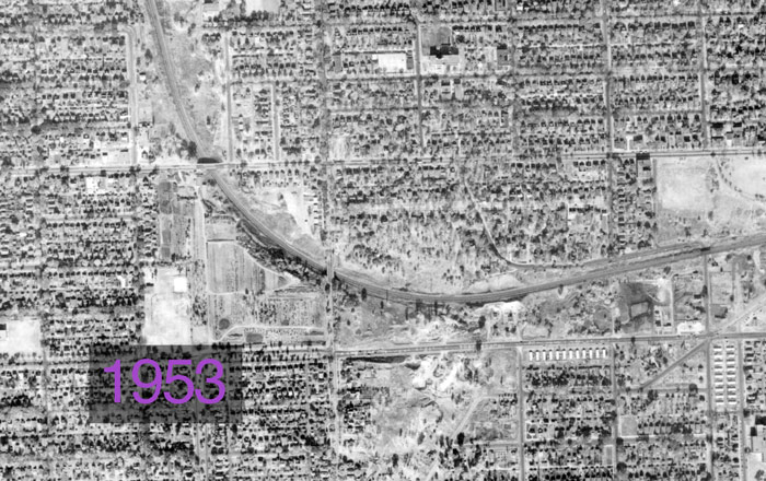


"[Met Council] staff recommended that a direct link between the parkway [and the downtown interstate system] be provided, as well as a link to the Short Line Road [former name of AMR]. That link would not be opened to traffic until the city could upgrade Short Line."


Even now, St. Paul engineers are said to be muddling over charts and maps, doing a study on the feasibility of making the road that goes nowhere, go somewhere. Maybe start somewhere, too....
But some things are best left with an air of mystery about them. The Short Line is one of those things... Wanderlust is basic to the human condition... The problem is most of us never can find the time to take a trip that has no predetermined destination.
That's where the Short Line comes in handy. It will take you nowhere. But it will do it quickly... [but] be careful of both chuckholes and speed traps.
Don Nygaard, director of public works in St. Paul, sees neither much humor nor much mysticism in the Short Line. "Without digging through the records," Nygaard said, "I really couldn't tell you what its purpose was."


AMR now carries about 11,000 cars a day. The temporary link would increase the traffic by 1,000 or 2,000 more vehicles during peak hours.
"The people should not have concerns that there is a hidden agenda for addressing the Ayd Mill Rod. problem for the future. Rather, it is a short-term connection for the summer's congestion problems,' City Council Member Bob Long said.
There is little chance that AMR would ever become the link between I-35E and I094 that once was envisioned. To permanently connect the two interstates would require an environmental impact study and upgrading AMR to freeway standards.
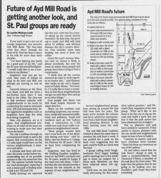
The city is halfway through an environmental study to assess the impact that construction would have... A citizens task force will consider the study results...
The AMR Coalition formed at about the same time to monitor the task force's work. It has pushed for a park on the land, even suggesting that the park could be built as a deck atop the road....
What we'd like to see done is for the city to dig up the road and build a park, but our fear is that the park option has been eliminated out of neglect." ...
Said O'Brien, a member of the task force for three years: "I hope that the powers that be are going to be looking over our shoulders, and I hope they learn something."


By connecting the road directly to the freeways, Gordon noted," you'd be taking about 10,000 cars a day that now use Ayd Mill and you'd be pulling them off city streets" at either end.
The citizens task force, using a weighted formula, in August voted on six proposals for Ayd Mill. The park got the most votes with 47; the roadway alternative chosen Friday received the fewest votes, 28.


"The council two years ago approved a two-lane connection plan, but the project was never begun for lack of funding.
No protestors were seen along the 1.5-mile stretch of AMR Wednesday, but Flaherty said police had received reports of possible acts of civil disobedience to come.
"The police are prepared and will not allow people to break the law or obstruct the road," Flaherty said. "Most of the neighbors are good taxpaying citizens, but there are professional protesters who will take any case and this is as good as any."


"One neighborhood has benefited while another neighborhood has suffered,” [a concerned neighbor] said. Meanwhile, he added, traffic overall will inevitably grow.
[Then-Mayor] Kelly will hold a public hearing Thursday at a school in the Highland Park area to present data from the yearlong test conducted by the city on the Ayd Mill corridor’s air, noise and congestion.
Traffic counts down Kelly aide Howard Orenstein said the results show that traffic counts went down at most locations after the connection was made, except for Ayd Mill Road itself and the Hamline Avenue exit. There were significant traffic drops on Lexington Parkway and Jefferson and Randolph avenues.
But [activist] Ludemann, City Council Member Jay Benanav and other connection opponents say the test proves that hooking up Ayd Mill to the freeway was a bad idea.
Overall trends shown by the data disguise noise and pollution increases at some recording locations, they said. Benanav said that even though air quality remains within state standards, it’s still higher at Hamline and Ayd Mill than at the congested intersection of Snelling and University avenues. He wants to return Ayd Mill to a two-lane road with no freeway connection. “A few years from now Lexington will find it’s as busy as before because traffic expands to fill the gaps, and that’s what will happen,” Benanav said.
“You’re bringing more cars, more noise, more pollution into the most livable urban core in the country,” he said. Orenstein said traffic would increase in the area whether Ayd Mill Road is attached to the freeway or not. He said Kelly is leaving open all of his options, including a possible connection of Ayd Mill at the north end to I-94 — a project that would cost millions of dollars and require completion of the environmental impact statement begun years ago.The four-lane connected road was left in place.

Council members also approved a resolution to "clarify the current and future status" of AMR....
Wednesday's council action called for a new community process to discuss the future of the road, which the City Council wants to be two lanes with a bicycle and pedestrian trail.

A community task force is asking the city for a $150K study [$162K in today's dollars] to analyze the issue and propose a makeover in keeping with their concerns.... The AMR she envisions would be something akin to a 35-mph landscaped parkway, with room for pedestrians and cyclists, that would end not at Selby but curl northward on a new route through an industrial area to hook up with Interstate 94.
In 2005, and environmental impact statement analyzed Kelly's proposal to turn AMR into a parkway and extend it one-third mile to the north to connect with I-94 at st. Anthony Avenue. But the project, estimate to cost $44M [$56M in today's dollars], was overshadowed by work on the Central Corridor and shelved.

 |
| [The I-94 bridge over the Mississippi River in Minneapolis.] |
This Sunday night, May 7, TPT (Twin Cities PBS) will premiere Part Two of our two-part documentary about Interstate 94. The half-hour program will begin at 7 p.m. and air on TPT MN.
Part Two of the documentary, entitled Interstate 94: Today and Tomorrow, focuses on the here and now as it relates to I-94 through the Twin Cities, as well as our continuing work to engage with communities along the interstate in an effort to develop a comprehensive, community-based vision for the corridor. If you are unable to watch this Sunday night, the program will air at the times listed below and will be available on our Rethinking I-94 project website starting next week. This website is located at the following address:
http://www.dot.state.mn.us/I-94minneapolis-stpaul/
Upcoming air dates on TPT
• Sunday, May 14 at 1 a.m. TPT MN
• Sunday, May 14 at 7 a.m. TPT MN
• Sunday, May 14 at 1 p.m. TPT MN
• Sunday, May 28 at 12 p.m. TPT LIFE
If you have not seen Part One of the documentary, or would like to see it again prior watching Part Two, you can do so by visiting the Rethinking I-94 project website noted above and scrolling to the bottom of the page. Part One of the documentary, entitled Interstate 94: A History and Its Impact, focused on the construction of I-94 in the middle of the 20th Century and the affect it had on the communities it bisected.
