 |
| [Cars drive back and forth to Dakota County over the potholes in the AMR trench in 2019.] |
Here are some highlights from the Minneapolis Star Tribune newspaper archive about Ayd Mill Road (AMR), Saint Paul's great mid-century sunk cost albatross...
According to a 1981 article [below]: "it's been 50 to 60 years since St. Paul identified the Pleasant Avenue corridor as a potential major roadway... the Minnesota Department of Highways conducted a public hearing, and the city and federal government included the corridor in the interstate system in 1957.."
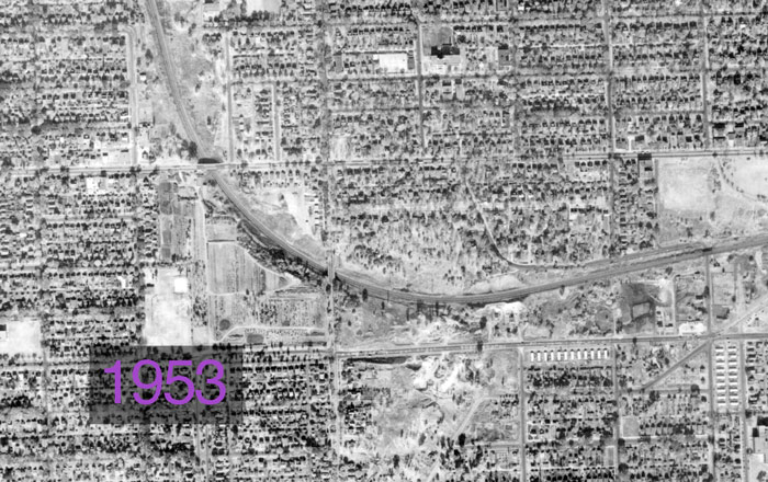
AMR was not technically part of the system, but a road was planned there regardless. As of 1953, it is a valley containing a well-used railroad line, the "short line" between the two downtowns.
1962: It begins...


The road is built in the valley. "This is not a highway to nowhere," someone says.
It is intended to connect the industrial midway area to the planned 35E freeway, which, unfortunately for AMR, will not be built for twenty years. Cost is $8.3M in today's dollars. My best guess is that the road is intended to be used by trucks for industrial purposes.
Then the road sits in the valley for twenty years, rarely used.
1981: 35E Finally Constructed as a "Parkway"; AMR is an Added Bonus


After two decades of neighborhood debate, lawsuits, protests, pressure from suburban and business interests, 35E is finally allowed to be constructed, provided there are no trucks and that the speed limit is restricted to 45 mph. The 35E freeway costs the state at least $200M in local funds, but the remaining expense (4/5ths) is paid for by Federal dollars.
Partially completing the on-ramps to AMR is included in this cost.
Article states:
"[Met Council] staff recommended that a direct link between the parkway [and the downtown interstate system] be provided, as well as a link to the Short Line Road [former name of AMR]. That link would not be opened to traffic until the city could upgrade Short Line."
Special note: The article includes quote from State Senator Marilyn Lantry, mother of current Saint Paul Public Works Director and former Council Member Kathy Lantry. That means Director Lantry is the second generation of her family to wrestle with what to do, and how to pay for, Ayd Mill Road quasi-freeway.
Also: Then late-Senate Majority leader Nick Coleman is also mentioned in the article, the father of the former mayor Chris Coleman, meaning his family also had two generations of dealing / not-dealing with AMR.
1987: Road Still "Goes Nowhere", Name is Changed


In 1987, Minneapolis columnist Doug Grow writes a snarky definitive history of the road.
Article states:
Even now, St. Paul engineers are said to be muddling over charts and maps, doing a study on the feasibility of making the road that goes nowhere, go somewhere. Maybe start somewhere, too....
But some things are best left with an air of mystery about them. The Short Line is one of those things... Wanderlust is basic to the human condition... The problem is most of us never can find the time to take a trip that has no predetermined destination.
That's where the Short Line comes in handy. It will take you nowhere. But it will do it quickly... [but] be careful of both chuckholes and speed traps.
Don Nygaard, director of public works in St. Paul, sees neither much humor nor much mysticism in the Short Line. "Without digging through the records," Nygaard said, "I really couldn't tell you what its purpose was."
1988: Task Force #1

The first AMR "task force" meets, convened by the Planning Commission. Options include tearing up the road, restricting traffic or allowing only one-way traffic or car pools, leaving it as is, and connecting it to the freeways on either end.
1992: A temporary car-pool connection is floated...


Because a bridge on the other side of downtown is out, Saint Paul Public Works' "traffic planners", with nudging from transit planners (!), floated the idea of opening AMR to 35E to "relieve congestion", only allowing car pools "during peak hours." There was a public meeting.
Quotes from the piece:
AMR now carries about 11,000 cars a day. The temporary link would increase the traffic by 1,000 or 2,000 more vehicles during peak hours.
"The people should not have concerns that there is a hidden agenda for addressing the Ayd Mill Rod. problem for the future. Rather, it is a short-term connection for the summer's congestion problems,' City Council Member Bob Long said.
There is little chance that AMR would ever become the link between I-35E and I094 that once was envisioned. To permanently connect the two interstates would require an environmental impact study and upgrading AMR to freeway standards.
I do not think this car pool connection actually took place...
1998: Task Force #2
Twenty-one years ago, people are already tired of talking about AMR. Options are again laid on the table, including leaving it alone, making "improvements" to it without connecting it, getting rid of it in favor of a park, re-building it as a two-lane street with a direct south connection, building a four-lane road with a direct southern connection but no northern connection, and connecting both ends as a four-lane highway.
Quote from the article:
The city is halfway through an environmental study to assess the impact that construction would have... A citizens task force will consider the study results...
The AMR Coalition formed at about the same time to monitor the task force's work. It has pushed for a park on the land, even suggesting that the park could be built as a deck atop the road....
What we'd like to see done is for the city to dig up the road and build a park, but our fear is that the park option has been eliminated out of neglect." ...
Said O'Brien, a member of the task force for three years: "I hope that the powers that be are going to be looking over our shoulders, and I hope they learn something."
The price tag for the study is $1.5M in today's dollars
1999: Planning Commission Wants a Freeway Connection


The Planning Commission votes to connect the road to 35E, while task force votes to make it a park.
Quote from the article:
By connecting the road directly to the freeways, Gordon noted," you'd be taking about 10,000 cars a day that now use Ayd Mill and you'd be pulling them off city streets" at either end.
The citizens task force, using a weighted formula, in August voted on six proposals for Ayd Mill. The park got the most votes with 47; the roadway alternative chosen Friday received the fewest votes, 28.
Article estimates costs for the connection as $55M, and the cost of building a park at $14.4M (both in today's dollars).
2000: City Council Votes to Connect Road with Two Lanes

The City Council votes to have a two-lane road connection, "splitting the difference" between the Planning Commission and task force plans. Then-CMs Kathy Lantry and Jay Benanav dissented, arguing that a connection would just shift traffic problems into other parts of the city.
Costs estimated to be "at least" $49M in today's dollars.
2002: Mayor Kelly Connects AMR to 35E with Four Lanes


From the article:
"The council two years ago approved a two-lane connection plan, but the project was never begun for lack of funding.
No protestors were seen along the 1.5-mile stretch of AMR Wednesday, but Flaherty said police had received reports of possible acts of civil disobedience to come.
"The police are prepared and will not allow people to break the law or obstruct the road," Flaherty said. "Most of the neighbors are good taxpaying citizens, but there are professional protesters who will take any case and this is as good as any."
Cost for the "test" is estimated as $700,000 in today's dollars.
P.S. This also happened.

2003: "Test" Stays in Place


After the "test", there was a public meeting. Some quotes from the article:
"One neighborhood has benefited while another neighborhood has suffered,” [a concerned neighbor] said. Meanwhile, he added, traffic overall will inevitably grow.
[Then-Mayor] Kelly will hold a public hearing Thursday at a school in the Highland Park area to present data from the yearlong test conducted by the city on the Ayd Mill corridor’s air, noise and congestion.
Traffic counts down Kelly aide Howard Orenstein said the results show that traffic counts went down at most locations after the connection was made, except for Ayd Mill Road itself and the Hamline Avenue exit. There were significant traffic drops on Lexington Parkway and Jefferson and Randolph avenues.
But [activist] Ludemann, City Council Member Jay Benanav and other connection opponents say the test proves that hooking up Ayd Mill to the freeway was a bad idea.
Overall trends shown by the data disguise noise and pollution increases at some recording locations, they said. Benanav said that even though air quality remains within state standards, it’s still higher at Hamline and Ayd Mill than at the congested intersection of Snelling and University avenues. He wants to return Ayd Mill to a two-lane road with no freeway connection. “A few years from now Lexington will find it’s as busy as before because traffic expands to fill the gaps, and that’s what will happen,” Benanav said.
“You’re bringing more cars, more noise, more pollution into the most livable urban core in the country,” he said. Orenstein said traffic would increase in the area whether Ayd Mill Road is attached to the freeway or not. He said Kelly is leaving open all of his options, including a possible connection of Ayd Mill at the north end to I-94 — a project that would cost millions of dollars and require completion of the environmental impact statement begun years ago.The four-lane connected road was left in place.
2009: The City Council Votes for a Two-lane AMR with a Bike Trail, Task Force #3 Begins

The City Council weighs in again on AMR:
Council members also approved a resolution to "clarify the current and future status" of AMR....
Wednesday's council action called for a new community process to discuss the future of the road, which the City Council wants to be two lanes with a bicycle and pedestrian trail.
The bike connection never happened, thanks to a lawsuit from a railroad company.
2013: Task Force #4?

By now the well-used road is an "ugly chipped-concrete bypass" [that] "spills traffic onto Selby Avenue.
From the article:
A community task force is asking the city for a $150K study [$162K in today's dollars] to analyze the issue and propose a makeover in keeping with their concerns.... The AMR she envisions would be something akin to a 35-mph landscaped parkway, with room for pedestrians and cyclists, that would end not at Selby but curl northward on a new route through an industrial area to hook up with Interstate 94.
In 2005, and environmental impact statement analyzed Kelly's proposal to turn AMR into a parkway and extend it one-third mile to the north to connect with I-94 at st. Anthony Avenue. But the project, estimate to cost $44M [$56M in today's dollars], was overshadowed by work on the Central Corridor and shelved.
2018: 5-Year Plan Proposes Spending $3.2M to Mill and Overlay AMR

With the fifty-five-year-old road close to un-driveable without major maintenance, the Public Works Department proposes a mill and overlay, typically a short-term fix.
Prediction: that $3.2M will be more expensive in 2023 dollars.
[See also the Ayd Mill Road community timeline, from a Saint Paul neighborhood group.]
3 comments:
Such an epic tale
I'm just grateful they re-routed that deathtrap entrance from St. Clair northbound onto Ayd Mill. I was once t-boned by a southbound semi whose driver changed his mind about exiting there. It was never a safe intersection.
Several suggestions for a problem that can be a multi-opportunity for Saint Paul. First, dam up both ends and fill the trough with water and make it a canal for a water transport system, heated during winter by a district community heating system that can supply heating for thousand of houses. At Winter Carnival time, the waterway could used for canoe races.
The awkward name Ayd Mill should be changed to a more Minnesota name - how about Minnesota's 10,001 Lake?
All of this could make Minneapolis people jealous of Saint Paul.
Post a Comment