 In honor of Saint Paul hosting the National Walking Summit, I have prepared a self-guided walking tour for summit-goers.
By the way, I love Saint Paul! I think there are some great walkable parts of my city. I could easily come up with a tour of the best possible five-mile walk through Saint Paul.
But I also think there are some real design tragedies that keep Saint Paul from being its most walkable, pleasant, and compelling self.
So, here you go! The walk is about 5 miles long, and takes you from the West Side to Rice Park. Give yourself about two hours, though you might go faster than that as you'll often be running from speeding cars.
 |
| [Link to step-by-step directions is here.] |
 Point of Interest #1. You begin your journey on the West Side Flats, on Robert Street, one of the worst streets anywhere in the East Metro.
Back in the early 1960s, this was a working class neighborhood with a tight street grid and small, walkable blocks. Shops and buildings and homes were all around you.
Today it is an industrial park in the shadow of downtown, and the sidewalks of Robert Street are noteworthy for being particularly narrow and horrid. In fact, when this street was first designed great light poles were placed directly in the middle of the sidewalks. At some point, an embarrassed engineer added tiny brick extensions to the sidewalk at each pole.
All around you are parking lots, empty falling apart buildings, and vacant lots. The smell of industry and blood lingers in the air. And you can see downtown!
(Note: biking here is borderline suicidal.)

 Point of Interest #2. Proceed towards downtown. You will notice that as you reach the 1920s-era Robert Street bridge, for some reason the street goes from two lanes in each direction to three (!) northbound lanes. It’s the age-old answer to the question: can it get any worse?
(A: yes it can, yes it can.)
Cross the lovely bridge and enjoy the view of the Mississippi. Savor this moment before you reach the dangerous porkchop island-laden intersection of Robert and Kellogg. Back in the early 1930s, Kellogg Boulevard was widened to accommodate more car traffic, and today it’s not very pleasant.
But lo! Ahead of you is downtown Saint Paul, full of historic buildings and walkable sidewalks. It looks great! It is almost seductive.
Don’t worry… we’re not going that way.
Turn down Kellogg Boulevard and proceed along the narrow sidewalk under the tracks of the lovely 1920s-era Union Depot train station.
Enjoy your walk through Lowertown while you can. It’s lovely!
 |
| [This sign is epically stupid and nobody pays attention to it.] |
 Point of Interest #3. OK You’ve reached the point where Lowertown turns into a freeway on-ramp. Here is where the walkability ends.
(At some point someone even installed a pillar to mark the occasion!)
Tread carefully, for cars speed off of the freeway here and will run you down in a heartbeat.
Approaching East 7th street, which is a US / state highway, note the first ever Super America gas station. How historic!
Also note that this is one off the only streets that connect downtown Saint Paul to the East Side, a huge part of the city that’s full of history, diversity, and no little poverty.
Also note that there’s no sidewalk on one side of the street. How is that even possible? Thanks Minnesota Department of Transportation!
You are now entering the “East Side death mile” portion of the tour.
 |
| ["Oof da": the Scandinavian phrase meaning, "you can't walk here but will try anyway."] |
Honestly, I have no advice for you. I hope you are athletic.
 |
| [Desire paths used by the poor.] |
 Point of Interest #4. OK You’ve reached Payne and East 7th! How'd you do it?
Anyway, good job. Look up the hill along East 7th and imagine trying to get there on foot. How’s it look?
Let’s take a left instead and walk around on Railroad Island, so-called because a century ago it was surrounded on all sides by railroad tracks. Today, it’s also surrounded by high-speed roads!
But there is hope. See the construction here? That’s a legit pedestrian improvement project underway. Thank you City of Saint Paul! They're realigning the previously-horrible intersection of Payne and East 7th to be kinda somewhat OK in the future, hopefully.
Walk along Railroad Island and enjoy the lovely old working class homes. This is a great part of the city!


Lafayette Road, so named for an old Victorian park that was once here but then demolished for a surface parking lot, is also terribly unwalkable. Plus thousands of government employees work here, surrounded by parking lots and high speed roads. As is the case with many of the government buildings in Saint Paul, there is no economic development anywhere near here, pretty much nowhere to eat lunch or walk to. Kind of sad, really.
Continue along University Avenue. Elsewhere, this is one of the main streets in the Twin Cities, lined with shops and a compelling sidewalks.
Here, it’s an empty windswept industrial unnecessarily-wide street full of speeding cars. Let’s walk to Capitol Heights!
Capitol Heights is another old residential neighborhood that’s been sorely neglected over the last century. Enjoy the neat old buildings and actual topography. There are some good views.

| [Sadly, Central Park is not on the tour.] |
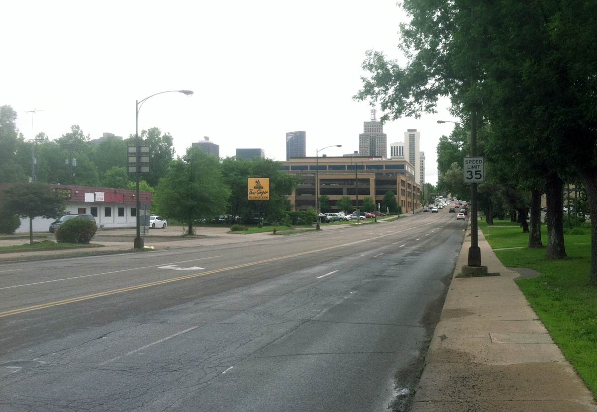
 Point of Interest #7. OK You’ve reached Rice Street, an utterly bleak and dangerous county road. This is also the center of the state government and state capitol area. Enjoy your walk along Rice Street, which has four and even five lanes at certain points.
Back in the late 1950s, this was a working class / African-American neighborhood with small blocks and lots of shops. Today this entire area is controlled by the state legislature, and they “improved” it in the 60s by bulldozing just about everything for parking lots and wide roads.
Hey, look to the left. It's the state DOT headquarters! Check out the high-viz crosswalks and heavy-handed signage. It’s almost safe to cross Rice Street here!
(Of course, lots of government workers and others use a “desire path” crossing at mid-block in either direction instead, scampering across the five lanes like well-dressed gazelles.)
 |
| [The MnDOT building crosswalk.] |
To your right is a classic early 60s modernist Sears building surrounded by a massive typically-empty parking lot. It’s most famous for having a Department of Motor Vehicles office inside. Cool!
 |
| [The Sears parking lot.] |
 |
| [Good view of the Cathedral.] |
Fun fact: Did you know that, just a block to the right, Kellogg has 14’ wide lanes? It’s true!
OK. Here we are at the Mulberrry Street crosswalk, which connects some major attractions like the History Center behind you and the Cathedral ahead of you. The corner has recently been marginally improved because, just over a year ago, a young woman was killed here while trying help her mother cross the street. It was terrible!
 |
| [The deadly crosswalk.] |
 Point of Interest #10. Continue down Kellogg, trying not to get hit by cars turning onto and off of Interstate 35E.
You’re almost to the really walkable part of Saint Paul!
There are a few remnants of the old city left around you. Cool stuff but you can't get there from here, so just take my word for it.
Turn right at the hockey arena. Keep going!
 |
| [You can almost see the walkable parts of downtown from here.] |
Rice Park, how lovely. I mean that sincerely. The nicest park in town. A great place for strolling around.

No comments:
Post a Comment