Showing posts with label worst planning contest. Show all posts

2018-01-05

Eight Biggest Twin Cities Urban Mistakes of 2017

[Just like it was before, only more shiny.]
There are lots of reasons to celebrate 2017, good things that happened like the pair of short-but-sweet curb-separated bikeways in both downtowns, lots of new housing projects replacing parking lots or other urban marginalia, new transit plans, and pedestrian / sidewalk improvements galore.

But let’s have some fun and bash some stuff instead. I was brainstorming this list while on a walk the other day. Perhaps you have something to add?

Caveat on the rules here: “errors of omission” don’t count. You can’t say, for example, “Minneapolis didn’t get rid of all parking minimums” or “Saint Paul didn’t build a bike lane on X Street.” Let’s focus instead on things that were actually done (or killed) over the past year.


#8. Nicollet Mall re-opens with buses and without a skyway connection


Some might disagree here, but I think it’s a mistake to re-make Nicollet Mall as a transit hybrid instead of a people-centered place. The design doesn’t really fix the main problem with downtown Minneapolis, which is the so-called skyway paradox. (Key problem: the lack of doorways, shops, stores on the street.)

And keeping buses on the street prevents it from truly being a café-centered place, where people could enjoy sidewalks and car-free spaces without having the noise and pollution of an idling bus waiting at the ever-present stoplights.


#7. Plastic bag ban ban

The legislature made a lot of mistakes while it devolved into a junior high cafeteria food fight, but for some reason the one thing everyone could agree upon was a ban on bans of plastic bags. Yes, that’s right: pre-emption on behalf of the plastic bag lobby, of all things.

Hopefully this is not a sign of things to come.


#6. Saint Paul’s abandonment of street fees


I still think Saint Paul should find a legal basis for charging street maintenance to non-profits and (state) government entities. Just throwing everything onto the property tax is a mistake, in my book.


#5. Killing the 4th Street Market District

One-lane 4th Street in downtown Saint Paul offers a golden opportunity to improve the streetscape, public spaces, and bike/walk access at almost no cost to the city. There was a study done to look at the options for transforming this marginal “street” into a useful bike/walk space.

Though it had support, it was quietly killed, I suspect at the behest of conservative downtown property owners.


#4. Half-assing the 38th Street bike lane

You can still park in it by the Fire Roast Café in the morning. Someone told me that the owner does this out of spite. Half-assing a bike lane is neither wise nor safe, and certainly not for an extra marginal parking space for a neighborhood coffee shop.

(The same thing happened on 40th Street by Chris and Rob's, IIRC.)


#3. Bus fare hike

Speaking of Metro Transit, raising the fares is not a wise nor morally defensible move. Every day I watch people dig for change to pay for the bus. This was a big tax on those who can least afford it, while we continue to subsidize the hell out of suburban riders, not to mention the mountains of taxpayer cash that go to reducing costs and congestion for those driving around in private cars.


#2. D-line de-listing

The aBRT plans are the single most effective and affordable transit investments on the table in the Twin Cities right now. The D-line is especially important, as it serves the poorest and most transit-dependent parts of Minnesota. This should have happened yesterday, and instead it's been demoted to "wish list" status.

(This might change, because I don't think the decision has been finalized.)


#1. Southwest LRT bid fiasco / wall thing

I don’t know what went on here, or here, but neither was good and both are terrible. The fact that this line continues to get delayed is just terrible news for a project that was already a mixed bag. This is quickly becoming an albatross for the Met Council, if it hasn’t already.


That’s all I could think of.

What did I miss? What’s on your list?


[Article is from 1987. See the rest at Magrino's Twitter.]

2013-11-26

4 Things Everyone Should Know About Block E

[Downtown's premiere Hooters.]
In case you missed it, I was on MPR today talking about the latest proposal to "remake" Block E, Minneapolis's notoroius failed attempt to improve Minneapolis' notorious dive block.

At this point, it's easy to throw eggs at Block E. Walking past a failed 90's concept mall, with (in the words of Larry Millet) a "cartoon of a development that presents architecture as entertainment" tends not to make one charitable. Today most of that "entertainment" sits vacant and abandoned.

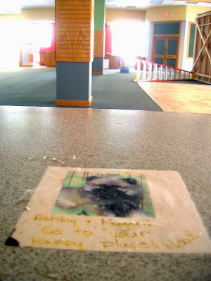
I was lucky enough to get to wander inside Block E thanks to the Made Here project, and it's fascinating. You find a time capsule of stores from the 2000s: most notably Borders and Gameworks, but also a pharmacy, movie theater, and a few restaurant spaces. The empty shops feel like an urban ruin, similar to a factory in Detroit, with paperwork from 2004 still sitting on an office desk, a straw hat left behind, instructions for employees still on the wall, random detritus strewn about like confetti. 

[Office in the Block E Borders, abandoned for over 5 years.]

[Chalkboard at the Block E Borders.]


[Borders sign: "Ashley & Megan, go to your happy place now."]
I moved back to Minneapolis from the East Coast about the same time that Block E opened up, and I remember the excitement with which downtown civic boosters unveiled the project. At the time, I didn't know many of the details of the project. I remember going with friends to see its debut and snickering like proper hipsters, but few people thought that the "critical link between the city's Hennepin Avenue theater district and the Warehouse District" would tank and sink so quickly.

Since then, watching the place casually implode has been a mix of schadenfreude and gloom. Back at the end of 2011, I had this metaphor:

The Block E Applebee's was the exact opposite of Nye's Polonaise Room. Now there's nothing alive in Block E save for The Shout House (shudder) and (somehow) the Mrs Fields' cookies-bigger-than-your-head establishment. Someday downtown folks will figure out that cities can't compete with the suburbs by replicating them, but need to create unique, locally-owned, walkable places. Keiran's Pub is a good start.

Meanwhile, Block E sits on Hennepin Avenue like a hippopotamus at a dog show.

(I'm rather proud of that one.)

Now I'm working on a radio documentary about the history of Block E for KFAI Radio (community voices), and it's been titillating to pore through old documents about the space.

Here's a rough primer for those of you too young to remember when R.T. Rybak was just the downtown reporter for the Star Tribune. (PS, that includes me. I'm not that old!)


Fact #1 - The Block's Previous Diversity

[Hennepin Avenue in the 40s, Block E on right.]
The next time you find yourself watching Purple Rain, pay attention to the background of the film. A lot of the downtown Minneapolis scenes are set against the backdrop of Block E in L.A., which at the time was a large mix of two- to five-story old brick buildings. (Actually, I just checked again and many of those scenes are Los Angeles, but my point is the same.)

Downtown Minneapolis used to be full of buildings like that, places with many storefronts, mixed-use everything, alleyways, and lots of street-front signage. And Hennepin Avenue between 6th and 7th was its epicenter.

According to my inadequate research, this one block was home to:

Restaurants: the Best Steak House, the Venice Café, the Casa Corando, McDonalds, and probably others.

[Block E signs.]
Bars: Moby Dick's, the 620 Club (previous to Moby's), Brady's Bar, Mousey's Bar, the Swallow Bar, and a music club named Goofy's Upper Deck (which was very hot in the summer).

Retail: Musicland, Harpo's Hot Licks (a record shop), Northern Lights (another record shop), Ryan Camera, two different Shinder's locations (newspapers and magazines), and much more.

Art galleries: most notable was the Rifle Sport Gallery (a converted game arcade), though I've heard there was a continually changing cast of others.

Many other things: two theaters (the World and the Schubert), a jewelry store, a barber shop, a bowling alley, a post office, Fantasy House (what you imagine), the Rand Hotel (rooms available by the hour), the Adonis (a place for gay hookups), and a secret tunnel under Hennepin Avenue that led to bathhouses across the street.

To find this kind of diversity on one block is impossible these days. In one of my interviews for the doc, Dennis Pearson described the block thus, from his early years growing up downtown:
I remember Block E used to be a lot of fun. That’s the place where you meet your friends before you go out to a concert, or to get a bite to eat, or sometimes you just stay at Moby’s. It was great for people watching, and they did a lot of things that you probably couldn’t do today. I remember if you turned in your AA medallion to the bar, they’d hang it up on the wall and you could drink free for the rest of the night. That used to happen every night. And one time...

[Me: That's terrible!]

It was so funny. It is terrible, but it's so funny too.

I’ve never seen a bar before or after with such a mixed group of people. Business men, pimps, prostitutes, neighborhood people, and people from all walks of life and they all got along. And you really didn’t have to worry too much. If someone was giving you a hard time, you just told the bartender or the bouncer. The bouncers would be over right away and take care of the problem and throw the person out...

Minneapolis had a million stories, and the shops at block E were at the heart of many of them.


[Block E in the 20s?]


Fact #2 - The Premature Tear Down Party

[Block E signs.]
From what I've heard (and it must be mentioned that many of the narrators' memories aren't necessarily reliable), the old block E was a somewhat respectable place until the 70s. Around that time, like much of the old urban United States, it started going downhill and became known as a center for various vices.

Reading through the news accounts of the time is confusing. You get a real sense of the conflict between the "old" diverse, dirty city and the "new" skyway-centered business-led city. Block E lay right at the crossroads of these two visions for Minneapolis.

What to do with the block came to a head when the Butler Square building was remodeled, and property owners began realizing the potential of the land that today we know as the Warehouse District. From that point on, various mega-projects were continually popping up in the area: City Center, a convention center proposal (where Target Center is today), the Target Center, the 394 parking ramps, Laurel Village (housing), etc.

Block E was in the way of a lot of this development, and so the city passed a plan in the late 80s to get rid of it. The city and the Downtown Council wanted to build something that would mimic the successful Calhoun Square development in Uptown, and had arranged with the developer of that project to construct an urban mall on the space of Block E. On October 18th, 1988 (or so), the city held a party to celebrate the impending razing of the buildings on the block. Later that winter, they all came down.

[The downtown entertainment map, c. 1984. The 9 buildings of Block E at bottom left.]

Much like George Bush's aircraft carrier party, the Block E celebration turned out to be premature. The planned development fell through, and for over a decade, the Block E area remained a surface parking lot.

If you're going to identify one common thread for downtown Minneapolis planning, one thing that our city is really good at, it's tearing down historic buildings and replacing them with surface parking. That's exactly what happened here.


Fact #3 - The Rejected Park Proposal

[R.T. Rybak, staff writer.]
Fast forward to the 1990s, and all sorts of Block E schemes keep popping up. By the late 90s, the were three main ideas. The first was to build a urban mall-type development. There were two proposals, but they each seemed similar: skyways, restaurants, a hotel, retail.

The second idea was to turn the now-empty block into a park, called "the garden of courage" and dedicated to cancer patients (or something like that). The rationale was the downtown needed more parks and green space, and this would serve as a "plaza" for the now-existing Target Center area.

A competing park proposal, by Forecast Public Art, was to use the existing theater and parking spaces as an open art space, similar to what today we'd call "pop up" programming. (This option would certainly have been the cheapest.)

In a way, the debates are eerily reminiscent of the current development proposals. You have a park, a stadium, a mixed-use development, a city-subsidized parking lot... La plus ça change.


Fact #4 - The Amount of City Money Involved Through the Years

[Moving the Schubert Theater.]
The final detail that can't be missed is how much money the city has spent on this block. It cost something like $9 million to buy it up in the 80s, something like $2 million to tear it down in 1988.

(Who knows how much money the city made while it was a parking lot, versus how much tax revenue they would have made if they'd left it as it was.)

Moving the six-million pound Schubert theater from Block E to Block D cost $4 million in 1999.

Subsidizing the Block E development cost the city $34 million in 2001.

And in 2010, the whole near-failure of a development sold to its current owner for the grand total of $14 million dollars.


Conclusion: Be Skeptical of Downtown Deals

[The latest rendering.]
For me, this whole sorry saga points to the fickle nature of downtown development deals. Studying urban geography, you see countless examples of revitalization and economic redevelopment approaches that might work in one place but completely fail when translated to another spot. The aforementioned list of failed urban redevelopment schemes is but the tip of the iceberg. (In fact, all things considered, maybe Minneapolis and Saint Paul don't have it that bad when compared to some other cities... at least it's not Autoworld.)

The ironic thing about Block E's failure is that the redevelopment, after over a decade of sitting as an empty parking lot, installed a lot of the same things that had been there before. In both incarnations of the block, you had a bookstore, a record store, an arcade, a restaurant (complete with rock musicians), night clubs, a movie theater, and even (eventually) a mammary-themed entertainment venue. The problem was that all the replacements were chain versions of the unique and local places that had been there before -- AMC Theater for the World Theater, Borders for the Shinders, Gameworks for the Rifle Sport, Escape Ultra Lounge for Moby Dicks, Hooters for Fantasy House, etc. That's precisely the opposite direction that cities should be going in. You'll never recreate suburbia downtown. You have to offer something far more unique, something that the ring road shopping malls can never have... density and diversity.

This doesn't  mean we shouldn't do anything. There are downtown development projects that worked out pretty well: the Target HQ building, the Loring Greenway area, and much of the infill development in the North Loop are particular favorites.

But if Block E teaches us anything, it should teach us to be skeptical anytime a developer comes to the city with a plan to "save downtown." And this is doubly true if the plan involves tearing down existing shops or businesses, no matter how seedy or disreputable you might find them.

The saving grace is that we're not compounding our mistakes by jumping on the latest urban redevelopment bandwagon, downtown casinos. The excellent "Made Here" project (curated by my friend Joan) is a great start at injecting some much needed street smarts into Hennepin Avenue again. And while this most recent proposal looks to me like an attempt to come up with something a bit generic ("Minnesota Modern"?), maybe that's a good thing. We don't need to re-create the wheel, we merely need to provide a space for the city that's already all around us to come to life.


[The French Connection, playing at Block E!]

Bonus:
As you can see in the 1984 "map", by the 80s a lot of it Block E was surface parking already. A friend of mine passed along this story:
From '80 to '84, I worked and managed the parking lots behind Moby's. People would park and pay, put their guns in their trunks and go have fun! I'd get calls at home at closing time from the attendant at the lot directly behind the bar asking what to do about the person demanding money from the till to replace the tire that had just flatted from running over a beer bottle. Or the people demanding compensation who had tried to sneak out the entrance to the lot on 6th St (the attendant couldn't see that entrance from the exit booth on 1st Ave) and had their windshield broken/roof damaged by the steel gate. The bouncers at Moby's were the toughest, most lawless in town, and one of them was actually charged with murder(?) for gunning down a patron on 1st Ave.

Bonus Too:

Almost everything I'm trying to say is said much better in this utterly amazing 14-minute film, Shinders To Shinders (1982), which features all kinds of Block E scenes, including the stairs of Rifle Sport, the entrance of Moby's, the Block E alleys, The Rand Hotel, and the doorway of Shinder's:

[Drug dealing dance performance. Click for whole video.]

The film ends with the funk/jazz beat refrain:
Clean it up,
Tear it down,
Minneapolis
Ain't no funky town.

There are all kinds of racial dynamics to this story too that I haven't even begun to talk about, and frankly, don't feel qualified to discuss. But they're very surely there.

2012-12-19

The #10 Worst Urban Planning Move in Twin Cities History

I was delightfully surprised yesterday to read Marlys Harris' Cityscape column in Minnpost, entitled "The 9 Worst Urban Planning Moves in Twin Cities History." Not only was Harris' list spot on (except for her Trader Joe's fixation), but the list completed some unfinished business that's been on my agenda for going on fifteen months now.

What seems like forever ago, teaming up with my good friend at Getting Around Minneapolis, we'd launched a Top 10 TC Planning Blunders of All Time series, calculated a definitive list, and started to catalog them. We got through 4 of the 10, before getting waylaid by circumstance and inertia...

Regardless, Harris nicely filled the void left by our sloth and ineptitude. Her list hits on all my favorite gripes: the skyways, Hiawatha "Avenue", Block E, and neighborhood NIMBYism... 

The discussion that follows on the comment thread is enough to leave any urbanist blogger (sustainably) green with envy, a variously pleasant and bitter debate over freeways and skyways and 'my ways or the highways.'

But one comment in particular made start thinking more about Harris' list:

Twin Cities Urban Planning Fiascos

So is "Twin Cities" limited to Minneapolis and St. Paul, or is that merely where the fiascos occurr?


It's a good question. Why are all the disasters located in Minneapolis and St Paul proper? Aren't there any planning blunders in the suburbs?

It got me thinking about how to include the suburbs in Harris' list. What would happen to this catalog if you tried to include things like 494 office parks, endless Woodbury culs-de-sac, or the Vadnais Heights (albatross) sports facility?

Well, let's consider the criteria that Harris is using in her list. She's critical of anything that's car-dependent. She's critical of places with disproportionate public subsidies. She's critical of designs that disrupt walkability. She's critical of anyplace that lacks transit and equitable street design. She's critical of using property values and density regulations to institutionalize segregation...

And how do the suburbs rate on those criteria?


#10 Worst Planning Move in Twin Cities History: All of the Twin Cities' Suburbs

[The culprit.]
Yes, you read that correctly. No list of the Twin Cities' planning disasters would be complete without including on that list all of the Twin Cities' suburban development that occurred after about 1952. And that describes pretty much everywhere that most people live, outside of Minneapolis, St Paul, a few of the inner-ring suburbs and some scattered dollops of our older built environment. (Granted, there might be a tiny tiny fraction of that suburbia that has some decent urban qualities, but its safe to say that 99.5% of this development is worse than anything you could find in the Minneapolis or St Paul proper.)

By every measure of good and bad urbanism, every suburb in the Twin Cities lacks walkability, decent transit access, density, and financial sustainability. When you throw in the subsidies like the Mortgage Interest Tax Deduction, Federal freeway investment, accelerated depreciation, subsidized sewer and road investments, and the occasional TIF district, most every suburb in the Twin Cities would make Block E look financially sound. 

I was talking with a urban planning colleague last night about Harris' list, and he was upset about the fact that criticism of projects like Block E threw a bad light on Minneapolis development deals. Calling Block E a disaster, he argued, made it easy for people who supported suburban development patterns to stereotype the central cities as development quagmires, corrupt places where good money goes to die. This, he argued, was not helpful...

He makes a good point. Any discussion of Twin Cities urban planning blunders needs to be considered in the larger context of American suburban sprawl. Any discussion of Block E or the Hiawatha Avenue design should keep in mind that, as bad as they are, they're still better than the vast majority of suburban land use. As bad as the Gateway or downtown St Paul urban renewal were for the city, those places are still vastly more walkable and sustainable than anywhere in Apple Valley or Elk River.  As bad as the Minneapolis skyways are, they're still much more "urban" and "public" than the Eden Prairie Mall or Richfield's Best Buy HQ. As bad as University Avenue's big box district might be, next to Plymouth or Eagan it looks like pedestrian paradise. And let's be clear, South Minneapolis NIMBYism has nothing on Edina.

So. With that in mind, I suggest an addendum to yesterday's Minnpost list. I submit that no list of Twin Cities "urban planning disasters" would be complete without including the vast ring of unwalkable autocentric sprawl that surrounds our cities like a sick yoke. Congratulations, almost all of Twin Cities suburbia. You just made the cut!

2011-10-21

A Modest Proposal to Save the Vikings

It goes without saying that the Minnesota Vikings are a local treasure. No Minnesota sports team has done more to dramatically lose. In fact, the Vikings are the only team this side of Buffalo that has found so many innovative losing ways, pioneering a uniquely depressing balance of inspiring talent and constant ineptitude rarely found anywhere in the world of overpaid grunting men.

[Artists' rendering of the proposed stadium complex.]
As you may know, the owners of the Vikings are currently spending millions of dollars lobbying local politicians to levy a sales tax on some of the poorest residents of the state in order to generate millions of dollars in new revenue for a real estate developer in New Jersey. All that is well and good, but how exactly will the stadium be built? There’s some debate over where the new billion-dollar luxury spectacle will be, how it will be paid for, how people will get there, and what sort of local economic impact it will have…

So, I wanted to throw my two cents into the conversation while there’s still time to affect the minds of the local politicians, including Governor Dayton, who are meeting right now in back rooms at the capitol working out the deal with Wilf’s lobbyists without any public scrutiny.

Here is a modest proposal that I believe will solve many of the so-called “problems” with the current stadium plan:


#1 The Walter H. Bachlenty (Target) Arena luxury stadium and hotel

Obviously, any football team that wants to lose in spectacular fashion will require a large, expensive, semi-outdoor stadium. There will have to be plenty of luxury boxes for local CEOs and medical device executives. The stadium will have to be large enough to give the Vikings inevitable dramatic overtime losses a feeling of pathos worthy of the fall of the Roman Empire. So, we spend a lot of money here.

[The new VIP-ZIP pilot program.]
(Interesting thought: a personal Segway sharing system modeled after the popular NiceRide program that would use dedicated “seg-sky-ways” so that employees of Medtronic and Boston Scientific can travel from their nearby corporate campuses right to the luxury boxes, bypassing all the messy parking lots and freeway onramps. You could call it “ZIP-VIP.”)

Here’s the brilliant part. In keeping with Vikings tradition of high-profile failure, and to honor all the hard-earned unpayable state government debt invested in the project, we would name the stadium after Minnesota’s strong tradition of losing presidential candidates. We will call it Water H. Bachlenty (Target) Arena. We could even erect memorial statues of each politician giving their concession speeches around the outside of the building!


#2 An Aquari-Sino at Block E

But, you might say, “How will we pay for this huge stadium? The state is broke, and has been for years!”

No problem. We’ll build a lucrative downtown casino at Block E, a building right in the heart of downtown Minneapolis that has sadly lay empty ever since Hooters and Applebee’s went out of business during the recent economic downturn.

(Whichever developer built that thing really messed up, boy howdy!)

What’s that you say? “Downtown casinos never work out, and become soul-sucking dingy blights where ever they’re built?”

Well, sure. That’s why we’re going to add a large publically financed aquarium component to the casino. My studies have shown that one of the primary reasons downtown casinos fail is because they don’t have enough architecturally embedded fish tanks. This casino will be different. It will be full of backlit sea creatures.

Close your eyes and imagine the “carps and craps” table. Block E will surely be one of the Top Three Aquarium Casinos in the World.


[The problem with the failed Duluth downtown casino and the failed Duluth aquarium is that they're too far away from each other.]


#3 “Sinking ship” themed Waterpark Convention Center

One of the other problems with the current proposal is that Arden Hills site is in the middle of nowhere, at a vacant bullet factory.

That’s why I am proposing a new Minneapolis Convention Center complex to add synergy to the Vikings stadium hotel development plans, which unfortunately will only be used eight times each year.

As you may of heard, the current Minneapolis Convention Center is struggling, and recently had to lay off half their staff. We need a new attraction to draw in lucrative tourism and convention business, and so I’m proposing a new “waterpark” convention hotel.

Special Bonus: In keeping with Vikings’ tradition and Minnesota state government trajectory, the waterpark could be called “The Sinking Ship.” Conventioneers could ride a special Vikings longboat that would sink into the water during each Vikings 4th quarter loss, projected onto the Jumbotron for vicarious televisual depression. The image of a sinking ship could be emblazoned on the stadium itself!


#4 MinneMonoRail

At this point you’re surely thinking, “Well, those are all good ideas. But Arden Hills is in the middle of nowhere! How will people get from the Block E Aquarium Casino to the new Walter H. Bachlenty Luxury Stadium and “Sinking Ship” Waterpark Convention Center?”

[The MinneMonoRail would be modeled on the successful Detroit people mover.]
That’s why I’m proposing a new modern “transit feature” that will connect our new tourist and entertainment amenities into a seamlessly integrated modern transportation network that rivals anything found in China or Belgium. We will construct a new “people mover” transportation line using an automatic train that runs from downtown to the luxury stadium without interfering with automobiles.

The magic of it all is this: there will only be ONE track, high up in the air. I call it a “MinneMonoRail.” Soon Minneapolis will be breathlessly mentioned alongside destinations like Las Vegas, Nevada and Detroit, Michigan. The future is now!


#5 Artistic Lutefisk Hall of Fame Museum & Cabbage Preservation Library

All this sounds expensive, to the untrained ear, I’m sure.

But luckily, the state of Minnesota recently passed a sales tax dedicated to environmental protection, arts, and culture called “The Legacy Fund.” And all that money is going to waste! What are all these “artists and “deer” doing with this valuable tax income? Not tackling each other, that’s for sure.

So, in order to use this underutilized revenue stream for productive economic development purposes, I propose that the new Vikings Mega-Convention-Aquarium-Casino-Monorail complex include an artistic Lutefisk Hall of Fame Museum and Preservation Library.

You might not know this, but Minnesota has a rich Scandinavian heritage! A lutefisk Hall of Fame would, at long last, pay some much-deserved tribute to some of the all-time great Lutefisk chefs, such eminent “fiskers” as Uwe Thorbløatt, Nancy Johnson, Soren Sorenson, and Inga Aårvindsonindöttir.

Never heard of those people?

That’s exactly why we need a Lutefisk Hall of Fame!

Plus, there are two added benefits: Lutefisk is already preserved, so we won’t need to do very much to preserve it. And secondly, the museum’s palpable stink will make the Vikings smell better by comparison. (Look what the garbage burner has done for the 2011 Twins!)


#6 The 2013 Arden Hills World Exposition of America Field

“You’re dreaming, Bill”, you’re probably thinking. “All this wonderful stuff will never happen here in little Minnesota. Nobody’s even heard of our state. How can we bring in so many tourists?”

They said the same thing about the Mall of America, and look at it now!

That’s why we’ll host a spectacular international festival. To kick off our new mega-project with a bang, we will host the 2013 Arden Hills World Exposition of America.

Think of it. Millions of people flocking to our little corner of the upper Midwest to marvel at the wonders of the future, at the latest cutting edge science and technology of our modern age. They will ride Segways onto the monorail and into the waterpark and up to the aquarium casino and up into a giant cheese curd themed roller rink / Large Hadron Collider, where they will be quickly accelerated PAST the speed of light and out into Ray Kurzweil’s singularity, just like what happened at the end of 2001: A Space Odyssey, only it would be Brett Farve sitting in the room at the end of the universe wearing a smoking jacket, waiting patiently to hug us and give us “massages.”

If we act now, we can make our dreams come true. Let’s a leave a real legacy and make our grandchildren proud.

[Artist's rendering of the proposed stadium from street level.]

2011-04-13

Planning Blunder #7: Lake Street K-Mart Explained!


Check out Alex's write-up of what happened over at the corner of Lake and Nicollet back in the 70s. The Lake Street K-Mart was our most popular nomination for the worst planning move in Twin Cities' history, and his explanation of how and why it came to be will blow your mind, man.


[This is what Nicollet and Lake was supposed to look like.]

2011-03-07

Planning Blunder #8: The Franklin / Hiawatha / Minnehaha intersection

[Part of a series on the Top 10 Twin Cities' Planning Blunders. See #10 and #9.]

Why it’s dumb: Huge dual freeway and rail over/underpasses in the middle of a dense walkable neighborhood creates an impassable pedestrian wasteland barrier.

What they were thinking: As best I can tell, the origins of current clusterf**k date back to the construction of the freeway along Hiawatha Avenue, which is one of the first things that Minneapolis and the Minnesota DOT did following World War Two.

Following the war, the intersection of Franklin and Minnehaha had two things going against it. First, it was the site of a big railroad interchange that belonged to the Chicago, Milwaukee, Saint Paul, and Pacific Railroad Company, which had a railyard just north of Franklin at the site of the current LRT maintenance facility.

Second, the intersection lay in the path of a proposed freeway plan that city transportation engineers envisioned along Hiawatha Avenue, that would eliminate congestion by speeding the booming number of cars Southeast out of Downtown Minneapolis all the way to Fort Snelling. This project killed two birds with one stone, and creating a new urban freeway and elevating the train tracks over Franklin’s at-grade railroad crossing.

[The program for the Cedar Avenue Grade Separation ribbon cutting ceremony on November 9, 1950 featuring a parade, a performance by the South High Band*, and a speech by Albert Bastis, chairman of the Post War Progress Committee.]

[It looks so nice in the cartoon. (That church is soooo toast.)]


[The gradual disintegration of the Franklin / Minnehaha / Hiawatha intersection, from 1938, 1954, and today. CLICK TO ENLARGE.]

My take:
Along with Lake, Central, and University, Franklin Avenue is one of the most pedestrian-oriented, diverse, and vibrant streets in the Twin Cities. It has a rich mixed-use walkable infrastructure, and happens to run through some of the most under-served communities in the city. And, at least these days, for the most part Franklin is pretty well designed and a pleasant street on which to walk or bike or shop or hang out.

Well, all except for the half-mile stretch between 19th and 15th Avenues where Franklin becomes a complete hell on earth, running through and under what have to be the least-inviting underpasses this side of Detroit. The current intersection has all the aesthetic appeal, pedestrian conveniences, and warm secure feelings of the dungeon levels from Super Mario Brothers.

[Walking from 15th to 19th Avenues along Franklin. (Dramatic Re-enactment.)]

Today, looking at the corner where these three streets come together, you might think that they’ve always been this way, that these corners have always been a pedestrian nightmare filled with rail tracks and freeways.

But, looking back at what the corner was like before the “Post War Progress Committee” completed their plan for “Progress in the City of Minneapolis,” the corner used to be a neighborhood street with rail tracks running through it. Where today you’ll find freeways and overpasses and endless amounts of concrete and car lanes, there used to be nothing but (probably slapdash) homes and shops along Franklin with a rail line running through them.

[The houses and shops along Franklin and Minnehaha in 1938. Img fm Borchert Map Library.]

And then someone got the great idea to build a freeway along Hiawatha, and used the opportunity of the at-grade rail crossing to extend the road into the middle of Franklin and all the way into to downtown. And it was this move that really separated the Phillips / Stevens Square part of the city from the West Bank / Seward part of the city, creating two separate Franklin Avenues that to this day have remarkably different characters and characteristics.

Its hard to really blame the car-blinded Progress Committee. This was the very beginning of the freeway construction era, and I’m sure building as many lanes of car capacity as possible was seen as an unmitigated good.


[How to walk on Franklin from 15th to 19th Avenues. Step #1: Negotiate the five lanes of speeding traffic coming off Minnehaha and Hiawatha Avenues.]
[Step #2: Wait for long time at small concrete island in between 4 lanes of traffic. Cross street. Repeat Step #2.]

[Step #3: Walk along dark concrete pillared corridor underneath train tracks.]
[Step #4: Cross large "no-man's land" on-ramp area and repeat Step #3 process for dark concrete underpass underneath freeway.]

[Step #5: Walk up hill along barren empty (ice-caked) path until you are finally in an area surrounded by buildings again. Total distance covered: 1/2 mile.]


But to this day, we’re still living with the legacy of the unfortunate decision to place a freeway in the middle of Franklin Avenue. We’ve spent a lot of time and money trying to undo this particular bit of progress, re-designing the corner in a futile attempt to make it work for both the giant stream of car traffic and the large number of pedestrian, bike, and transit users in the area, all while trying to cultivate density around the light rail station.

There are options for improving this corner, the most obvious being a roundabout-style intersection with lots of crosswalks. (Not sure how that would work…) But its almost impossible to imagine any sort of decent transit friendly walkable treatment for this corner that didn’t involve getting rid of the Hiawatha freeway that funnels thousands of cars into the neighborhood. As it is now, the Hiawatha /Minnehaha/ Franklin clusterf**k corner is a lost cause. For the entire ¼ mile radius of the Franklin LRT stop, as there is nothing here but concrete and freeway overpasses.** And that’s why it’s the #8th worst planning blunder in the Twin Cities!

[A lonely woman begins the lonely trek through the 1/2 mile Franklin Avenue gauntlet.]

[For what its worth, these two sides of Franklin Avenue might as well be separated by a giant moat filled with sharks with freakin' laser beams on their heads.]

* Not the same South High.
** And the Cabooze.

2011-02-17

Planning Blunder #9

Alex's lovely write-up of Planning Blunder #9 is up over at his blog Getting Around Minneapolis. Check it out!

[The view from below our Twin Cities' #9 dumbest planning move.]

2011-02-15

Planning Blunder #10: Saint Paul’s (and Minneapolis’s) low-density Port Authority developments on high-density urban land

Why it's dumb: Suburban-style buildings with parking lots and single-story, single-use auto-centric buildings right in the heart of the city.

What they were thinking: I chatted with a knowledgeable planning professor at the University about each of these decisions to get a perspective about why planners and developers might have made the decisions they did. I learned that the St. Paul Planning Authority development was all done on old railroad land. S/he said that back in the 60s and 70s the kinds of developments they built were very ordinary. However, s/he said the SPPA stuff along Phalen Corridor stuff is far better, while the development along Plato Boulevard is also rather boring and pedestrian (i.e. anti-pedestrian). Finally, during the 60s through the 90s, the only kind of development you could get financed by the banks was this sort of basic suburban style stuff, even if it was located in the middle of the city.

My take: This was a surprise candidate. And in retrospect, this might not seem so bad. But I think you’ll find that, as time goes on, and as University Avenue becomes a dense transit corridor, the St Paul Port Authority’s low-density development and office park style parking lot-centric one-story fabric won’t be doing much to help revitalize anything, and will prove to be a difficult area to connect to the rest of the city.

The Saint Paul Port Authority is a mysterious entity, and to be honest, I don’t know that much about it. What I know about port authorities comes from Robert Caro’s famous book, The Power Broker, where you learn that the Triborough Bridge and Tunnel Authority was the bureaucratic loophole through which Robert Moses’ drove his fleet of bulldozers. Authorities, in that light, seem to be public/private institutions that can take out loans and raise money for a specific purpose, which is usually associated with economic development and revitalization.

Compared to Moses’ notorious megalomania, the one in Saint Paul is sweetness and sunshine. They have the unenviable job of figuring out how to re-use vacant industrial land in Saint Paul, to retain and grow industrial jobs in the city, and to get economic development flowing the most difficult problem areas such as the old 3M Campus on the East Side. Any one of those things is a problem of windmill tilters, and so far it seems the SPPA has done a good job with them. (For example, the Phalen Corridor project is really nice, in my opinion, and has some density and mixed-use characteristics that would make any planner jealous.)

[Leafy green office parks in Energy Park.]

[The car-centric townhomes along Energy Park Drive.]

But, that said, some of their older development is woefully lacking in good urbanism. For example, take the Energy Park corridor, which is a large stretch of the city that used to be rail yards and that includes the large Bandana Square complex. There are a lot of great things about the industrial / residential development that went in along there, including the environmentally efficient shared steam generation and the general idea of keeping jobs close to large population centers.

But the residential development along Energy Park wouldn’t be out of place in suburban Shakopee. Its separated from the street by a moat of parking lots and berms, and has that culs-de-sac maze dynamic whereby only those who know where they’re going can find where they’re going. Plus, the Bandana Square “festival marketplace” shopping mall, after a brief run of occupation in the 90s, turned out to be a bust (“office center”) and is now only home to a clinic and the Twin Cities Model Railroad Museum. To my mind, the Energy Park area represents a missed chance to create a real urban space.

[The Westgate Business Center on the Minneapolis border.]

But that’s not even the SPPA development that really irks me. That honor goes to the Westgate Business Center developments along University Avenue up by the border with Minneapolis. I’m not sure when these were built, but they look like a similar mid-90s development. They have the same one-story parking-lot-moat qualities that you’ll find in any suburban industrial office park. The problem here is that they’re located along University Avenue, right at the apex of one of the city’s premiere transit corridors.

Maybe this kind of development looked good when it was built, but in ten years when University Avenue is crawling with people and there’s a nice train running down the middle of it, all this sprawled out parking lot land is going to be a what Jane Jacobs might call a “great blight of dullness.” So, despite all of their good work, despite their industrial accolades, the Saint Paul’s suburban style developments get the #10 Planning Blunder award.

[The Westgate development would fit right on on Woodbury's Radio Drive.]

2011-02-14

Introducing The Top 10 Planning Blunders in Twin Cities' History

Each year when winter takes hold, sometime between Saint Crispin’s Day and Festivus my thoughts inevitably turn to darkness and negativity. This happens every year in spite of the Celexa prescription, the full spectrum sunlamp, the Glade Plugins, the ocean sounds playing on a loop in my living room, and the subscription to the Kitten-of-the-Month club. Every year, despite all intentions to stay positive, my spirits deflate like a Metrodome roof, my thoughts became critical and I ponder all the ways that my Twin Cities have been wronged through the years. I begin to spiral out of control into a deep nexus of Lost Twin Cities’ episodes, Studs Terkel books, and Rondo Days memorabilia.

But this year as I hit my urban nostalgia nadir, as my chin scraped the bottom of the sidewalk barrel, plying up the asphalt to reveal the brick paving stones beneath, I finally did something about my despair. I asked you, the good readers of Twin City Sidewalks, to write and send your ideas about the worst planning mistakes in Twin Cities’ history. And, much to my surprise, you responded in wave after wave of embittered euphoria with a veritable catalog of wrongs and mistakes made through the years, with a great and meticulous list of things that should not have happened but did anyway.

There were wonderful suggestions from all kinds of people, many of which I found to be surprising. They ranged from the Minneapolis Art Institute not being built in a central place to the existence of the Quarry in Northeast Minneapolis to that semi-useless bicycle bridge between Franklin and Lyndale to Block E (ugh!) to the 40mph 35-E parkway in St Paul to our now-notoriously anti-triumphal Mall of America Field at Hubert H. Humphrey Metrodome.*

And, using this list as a guide, my comrade-in-urban-blogging Alex Bauman and myself gathered together one winter night at "the best remnant of the 40s," the SPMC on University and Snelling, and narrowed the nominations down to a “top ten list” of blunders.

["Oh Magic 8 Ball. Will Block E ever be even slightly cool?"]

Of course we proceeded scientifically, following the best practices of top-ten planning determination procedures. We conducted a thorough reductions analysis using a full accounting of existing conditions. Then, employing asset-driven outcome-based opportunity and constraints study inventory charts, we ran the list through a stochastic aerial projectile-derived cartographic representation selection process (which I won by a score of 140 to 75). Finally, we utilized a repeating aleatory six-sided probability model over a directed qualitative libation focus group discussion.

In the end, our scientific implementation phase rendered complete results that appeared to represent the best interests of all the project stakeholders. We found there were two main questions: How stupid was the decision? And secondly, How detrimental was the decision? I.e. some of our planning mistakes might have been, in retrospect, monumentally dumb. But while dumb, they might have also had, in retrospect, a silver lining that had good outcomes, or alternatively had not had severe impacts that proved to be overly destructive to the Twin Cities urban fabric as a whole.

So, placing our candidates into a carefully weighted calculation matrix that balanced two vital concerns, we formed a summarily prioritized list of what is, without doubt, the definitive subjective representation of the Twin Cities Top 10 Planning Blunders.

In one way, I feel bad having created this top 10 list. Poor city planners have enough problems in this day and age. They don't need to receive continual criticism from the very people (planning geeks like myself) who should be supporting them, understanding them, and even loving them in a non-physical admiring-from-afar kind of way.

On the other hand, some of this stuff was really really dumb. These are things were probably dumb even when they seemed like great ideas at the time, but have only become dumber and dumber as the years have gone by, festering on the urban landscape like a Franklin Avenue pothole. And so, beginning tomorrow, we will bring you #10...

[Surprisingly, Riverside Plaza is NOT one of the Twin Cities' Top 10 Planning Blunders of All Time.]

*Still not as bad as the Louisiana Superdome.