Showing posts with label desire paths. Show all posts

2018-08-01

Walkability is in the Details and Cities Keep Neglecting Them


One of the most critical things I’ve learned about active transportation and street design is that you have to use it to understand it. The 1000’ birds-eye view from which most engineers or architects look at a problem does not to justice to the particular demands of creating a walkable space. Similarly, the 40 miles per hour windshield perspective leaves a lot of important factors out of the picture, and many decision-makers that only see projects from behind their steering wheels or peering through an open window. So many important design details are lost. Nothing compares to actual street-level use of a sidewalk.

[The Wabasha Bridge and the West Side.]

Here’s a great example of what I mean. Way back in the winter of 2015, Ramsey County began tearing down the old county jail built along the bluff at Wabasha and Kellogg Boulevard. It’s a prime spot at the heart of downtown, and the county was hoping to spur interest from developers in building something here.

(So far, they’ve had one serious offer. Unfortunately it came with a huge caveat: a demand for a huge publicly funded parking lot. Fortunately, the County rejected the proposal.)

One consequence of demolishing the building, though, was that it removed the sidewalk access to half of the Wabasha Street bridge, one of the critical pedestrian and bicycle links between downtown and the West Side where I live.

I found this out the hard way one winter morning when I began walking up the sidewalk of the bridge on my way downtown. It was a winter day, and the sidewalk was nicely cleared.


Unfortunately, more than halfway up the bridge, I found a concrete barrier with the announcement SIDEWALK CLOSED and a fence installed.

[On that day, the closure would have added 3/4 mile to my walk.]
At this point, there was no way on or off the bridge sidewalk, other than a staircase that led down to an island in the middle of the river. My choices were a) to walk back the way I came, run across a busy road, and walk back on the other side a total of 3/4 of a mile or b) hop the fence and continue walking on the dangerous icy margin of the road while cars sped blindly around the blocked-off corner.

Like any good militant pedestrian, I hopped the fence. It was harrowing.

Later that day, on February 10th, 2016, I emailed my Council Member and West Side neighbor, Rebecca Noecker:

Walking across the bridge this morning was a delight until I reached the middle of the bridge. Apparently the city is closing the sidewalk access halfway through the bridge on the West side. For someone on foot, the only if you want to get across the river are to go down the stairs to Raspberry Island, turn back and walk across the bridge on the other side after crossing the street (only legally back at Filmore, which is quite a walk!), or continue forward and have to hop a jersey barrier and almost get hit by turning cars, made worse because of a fence sign placed right in the sightline. You cannot cross to the other side of the bridge because you will fall to your death. (This has happened once.) 
None of those options are good ones. The city should either keep access open to the crosswalk or close it completely on this side of the street.

Closing off the sidewalk might have seemed like the prudent decision for the County when they planned the demolition, but in reality, it’s a meaningful hindrance for walkability on the West Side. For many pedestrian trips to and from the West Side, having the sidewalk closed means crossing busy streets one, two, or three times. That might not seem like much while you’re driving around or looking at a map, but over time it matters for creating a walkable place

What’s worse, there was no meaningful end point for this needless detour. Nobody at the County has any idea when or if this site will be developed. Waiting for a new building and sidewalk to be built at this bridge might take two years or two decades.

Since my 2016 email, I’ve been chatting once in a while with Council Member Noecker about the sidewalk. According to her, she’s been emailing the County regularly, every few months, to check in on getting the sidewalk re-opened.

Flash forward to today, and it’s two-and-a-half years later.

According to Council Member Noecker, earlier this year the County budgeted money to install an “interim” concrete fence that would allow the sidewalk to be re-opened. Initially there were problems when the installation did not make the sidewalk wide enough, and they had to be tweaked again.

[From February 2016 to July 2018 is two and a half years.]

Finally, just last week, I saw a crane lifting the concrete jersey barriers off the bridge sidewalk and re-opening it to the public. The other day I walked over the west sidewalk of the Wabasha Bridge. 


To many people, this might seem like a very small detail, almost inconsequential. But to me, it was an important step toward making sure that walkability and access are always included in urban street projects. Having both bridge sidewalks open and available to people will make a small but meaningful difference in people’s lives.

PS. There's Always More

This just crossed my desk from a friend. It's a pedestrian closure on Snelling Avenue, another street that is difficult and dangerous to cross on foot.

[Photo taken August 2018.]
Here's the email he wrote:
CM Tolbert and Director Lantry, 
The lack of a safe pedestrian detour around the construction at Snelling & St Clair was brought to my attention this morning. This is completely unacceptable. First, there shouldn't be a sidewalk closed on Snelling Avenue less than a block from an A-Line station. The parking lane should be protected with jersey barriers and made pedestrian accessible for the entire length of the construction zone. No one should be forced to cross Snelling Ave twice to reach the transit station. Second, the "sidewalk closed" sign should be moved to the (only slightly) safer crossing of Stanford. Once the forced crossing is established at Stanford, there should be a painted crosswalk with a middle-of-the-road sign stating "state law requires drivers stop for pedestrians." 
Finally, this happens nearly every time there's a project that necessitates the closure of the sidewalk. Public Works needs to create and enforce a comprehensive plan to address this during the permitting process. If a sidewalk is to be closed, then the contractor must do a better job of accommodating our most vulnerable right-of-way users. 
Please address this specific instance today and work to ensure this is preemptively addressed for future construction projects by creating appropriate procedures.

When it comes to walkability, the devil is in the details. And in Saint Paul, we often get those details wrong.

2014-09-18

Preserve the South 5th Street Sidewalk

[One of the old rights of way on the West Bank.]
I’m a man prone to shortcuts, and I’m not alone. Most people who walk or bike around the city have their own bag of tricks. People go through parking lots or alleys or the wrong way down a one-way street. We walk in bottom-up ways that resist the abstractions of top-down maps: desire lines and the smallest pedestrian protests.

Earlier this summer, I was startled to find one of my favorite shortcuts fenced up.

[While I was taking this picture, a woman climbed over the 5' fence.]

Years ago I wrote about a particular spot on the West Bank, the city-owned vacant lot on Cedar Avenue where 5th Street and the Dania Hall used to be.

Here’s what I said about this neat Minneapolis shortcut back in 2010:
But there’s something more at work about this act of sidewalk resistance. What at first appears as transgression may just be an act of restoration. Not too long ago, before the engineers of ‘urban renewal’ got their freeway’d fingers on Cedar-Riverside, this particular vacant lot used to be a public street. South 5th Street runs, very awkwardly, into the back of this spot, dead-ending into an access alley. My guess is that the 60s planners chose to cut off the street to keep traffic from congesting Cedar Avenue, which became a key through-way for traffic between the awkward intercourse of Interstates 94 and 35-W. (That’s one reason why Cedar Avenue, which runs through one of the most pedestrian-heavy parts of the entire city, is a four-lane, parking-deprived, narrow-sidewalk’d travesty.)
Meanwhile, even after all these years, this bit of gravel covered ex-street could not be repressed. Just because some plan had it marked for a building didn’t mean that it didn’t make a lot of sense as a connecting point for foot traffic. This spot is haunted by the ghost of sidewalks past. The old corner of 5th and Cedar, strangely still marked by a stoplight, continues to whisper at the feet of the adventurous. And this sidewalk, which seemingly sprang from out of nothing, might merely mark the long-dormant rebirth of old Cedar Avenue. It may be the first sign of a spring in your step, after a long winter of concrete and modernism.

Since then, the city installed way finding signage and a new traffic signal at 5th, and even added a Nice Ride station in the lot for a time. And just this month, after a half-century of treating people walking on the West Bank like lepers, they’re finally reconstructing Cedar Avenue to expand the sidewalks and improve one of the most dangerous and inhumane spots in the city.


[Expanding the sidewalks on Cedar Avenue after fifty years of neglect.]


That’s why this summer’s 5th Street fence was so surprising. Back in June, when the fence went up, I spotted this poster around the corner at the Hard Times:

[Hard Times democracy.]


[Where the sidewalk ends.]
At the time, I'd emailed a few folks at the city and found out that the fence was part of a short-term promotion for this summer’s World Cup. The Nomad World Pub had paid the city some sort of fee to use the lot during the three-week event, and turned the lot into a (ethically dubious) favela-themed exhibition space. In other words, it was a short-term thing.

So I shrugged, grumbled a bit to myself, and thought no more about it. I even went to the Nomad a few times to watch a match or two.

Except that the fence is still there, and it’s September now.

I asked the bartender at the Nomad about the space, and he shrugged his shoulders and shook his head. “It was supposed to be temporary,” he told me. “But the city hasn’t told us to take it out. So we’re just using it for things once in a while.”

What is an Alley Worth?


[Privatization of public sidewalk.]
There has been a lot of urban design violence done to the Cedar-Riverside neighborhood over the years. What had been an intact tightly-knit street grid was transformed into super-blocks hemmed in by freeways.

Cedar Avenue in particular was designed to maximize car traffic at the expense of anyone living in or walking through the area. The powerful institutions on the West Bank (the U of MN, Augsburg, and the Fairview Hospital) are continually buying up housing stock and expanding their parking lots and (often poorly designed) institutional campuses.

The last thing the city should be doing is fencing off more of the access points that people use to get around.

How much is an alley worth? Don’t people on the West Bank have a right to walk around the city?

I don’t often put up ‘calls to action’ on this site, but I sent an email to Abdi Warsame's office, the city council member for this part of Cedar-Riverside. Feel free to join me if you value what’s left of old 5th Street.
 
Dear Council Member Warsame:

I work on the West Bank campus of the University of Minnesota, and am writing to express my desire to see the sidewalk at Cedar and 5th opened up again. It was fenced off during the summer to expand the patio next to the Nomad Pub, but I believe it is important to maintain access for people walking around the west bank. Historically, 5th street provided a key connection for people crossing Cedar Avenue and getting around the neighborhood.

The city owns this property and should keep it open to the public.

Sincerely,

[The expanded fence on Cedar Avenue.]

Update:

I received the following email from CM Warsame's office in reply:

Thank you, Bill for contacting us.  We understand that this is a space that provides a key connection to both sides of Cedar Ave.  It is important to highlight, however, that this is not a public sidewalk.  It is actually part of the lot that the City owns and therefore private property.  As you mentioned, the Nomad Pub leased the property over the summer.  That lease has expired and this passage will be re-open very soon.

We appreciate that fact that you took the time to contact us and advocate for community issues that you feel are important.

Enjoy your day,
Marcela

My only thought is that saying "this sidewalk isn't public, it's owned by the city" seems like an oxymoron. Aren't all sidewalks owned by the city? If city land isn't public, what is?

2014-06-25

Why 'Sidewalk Closed' Signs?

["Pay Attention to this Sign!"]
Since I started this blog in 2005, I've taken pictures of a great many things: detritus, idiosyncratic signage, shop windows, doorways, lampposts, temporarily abandoned dogs...

There are also lots of sidewalk pictures that don't make it: interesting buildings, random sunsets, etc. For a photos to graduate to an actual blog category, there are two basic requirements.

First, the object, infrastructure, or situation has to grab the eye. The truly mundane -- think of doorknobs or gutters -- is not visually interesting enough to merit photographic documentation.

Second, that visual thing has to reveal something about how infrastructure affects our daily lives. Our built environment typically sits in the background. All around us things are silently "doing work" from the corners of our eyes. What happens when we look?

Oddly enough, once I acquired a dgitibal camera, one of the first things I began taking pictures of were 'sidewalk closed' signs. Why 'sidewalk closed' signs?

It all began with this photo, taken in 2006 near Hamline University in Saint Paul:

[The original 'sidewalk closed' sign.]

I remember like it was only yesterday when I happened on this scene. It seemed to sum up so much about our city streets and daily life.

There was one simple reason...

Everyone Ignores These Signs

[They also tend to ironically block the sidewalk even when not used.]
There is little on this earth more functionally useless than a 'sidewalk closed' sign. A fence? Now that's useful. Concrete barriers are semi-useful.

These signs? They make a mockery of signs.

If "freedom" is the degree to which people are able to overcome their environmental obstacles, pedestrians are by far the most liberated mode of travel. In a car, one little orange barrel can keep you from your destination. On a bike, a well-placed set of stairs might force you to dismount.

On foot, it takes one hell of a fence to stop you from walking where you want to walk. Hence desire paths, razor wire, parkour.

Almost everywhere that 'sidewalk closed' signs exist, people ignore them. They walk around. They walk in the street. They push the sign to the side.

For the most part, people walk where they want to walk. People walk where they feel safe, and along the most direct path they can find. Unless you're German, no amount of signage will stop you if you think it's the best way.


[The only conceivable purpose of these signs is to provide liability relief.]

Abstract v. Lived Space

The difference between expected theoretical behavior of people and actual real world behavior of people is akin to what urban theorists call "abstract vs. lived space." The concept comes loosely from French sociologist Henri Lefebvre (also quoted in my recent Minnpost column).

Basically, abstract space describes the theoretical spatial relations between people, buildings, technology, etc. Abstract space is how we think of things operating in maps, models, and stories we tell about ourselves. Typically these stories are relatively simple, "rational", efficient, hierarchical. Think of the rules the rules of a highway: keep right unless passing, zipper merge, don't speed, etc. That is abstract space.

Lived space on the other hand is what actually happens in the real world. Lived space encompasses the everyday resistances of actual behavior, the various ways that buildings or people or technologies escape their stated intentions. In lived space, people speed. Buildings fall apart. Pavement cracks. Machines stop working. The world fills with conversations and daydreams.

In this example, the 'sidewalk closed' sign perfectly illustrates the difference between these two conceptions of space. In theory, all pedestrians obey all signs. If the "sidewalk is closed" for whatever reason, people cross the street and continue on their way using the adjacent sidewalk.

In the lived space of the real world, people are tired when they walk, can see the sidewalk right in front of them, don't want to cross the street, and can easily step around the meaningless sign.

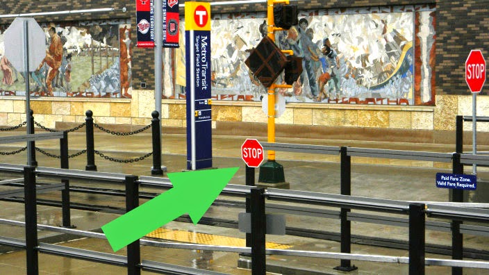
[A stop sign on the transitway that most people will ignore.]

[A "pedestrian stop sign" that most people will ignore.]

And This is Why We Must Walk

As designers, we ignore lived space at our peril. I often see design approaches that seem to dwell completely in abstract space, where the actual behavior of people seems irrelevant to the stated goals of an urban situation. This might be bike racks, architecture, street design, or whatever.

Almost always in these cases, "desire paths" form around the poor design. People vote with their feet. If you design a space or situation contrary to the actual behavior of most people, you'll find yourself ignored.

And this is why engineers, architects, decision makers, and planners must actually use the things they are building. If you don't take the bus on a regular basis, you probably have no idea how the bus is used. You don't see how people sit, interact with each other, use the payment devices, or negotiate the bus shelters. You can't do a good job designing or planning a bus system unless you actually use it.

The same is true for sidewalks, crosswalks, bumpouts, and pedestrian signals. Unless you actually walk around regularly (not just once), you won't understand how people walk and use streets in workaday lived space. And you'll end up designing things that are completely ignored... like 'sidewalk closed' signs.


http://tcsidewalks.blogspot.com/2013/05/donate-to-this-sidewalk-blogger.html

2012-06-12

Other City Sidewalks: West Palm Beach


They say that walking in Florida is like jazz dancing about bad architecture. It’s an inherently ugly clash between irreconcilable enterprises, and you have to improvise continually to get where you’re going.* To my bitter eyes, Florida is an incarnation of baby boom fantasy, the great 20th century escape valve, which is why the automobile is almost the only ingredient found in the stew. A pedestrian in Florida is a vegetarian at a steakhouse, an ice cream truck in January, a bicycle at the Auto Show.

In last year's big study on pedestrian safety released by the DC advocacy group, Transportation for America, Florida swept the top four spots on the "Most Dangerous Metro Areas" list. It was the kind of dominance not seen since the '92 Dream Team.  It’s almost as if Florida's cities were intentionally designed to kill people on foot. (That suspicion, by the way, lingers in one’s mind when contemplating the number of old people who have self-marooned along the coasts, and how the locals must feel about this demographic.)


[Typical sidewalk.]
[Typical sidewalk cyclist.]
[Typical bus stop.]
[Typical sidewalk denzien, typically with a cardboard sign.]

A lot of people might assume that nobody walks in Florida because it’s too hot and humid outside, and yes, there is truth to be found here. Just walking around in early May (!), I found my shirt drenched from the humid air that surrounds you like fog. But much like Minnesotans' insipid whining about winter, there are ways of dressing, times of walking, and designs for cities that minimize the heat. Just like in Minnesota, weather becomes an excuse for depressing sloth. (It's too hot, so we might as well stay on the couch instead of opening the front door.) The truth is that the weather is a convenient excuse, an atmospheric coincidence that exacerbates the basic problem: walking in Florida is demoralizing because most every part of every city is an alienating unbeautiful shadeless inconvenient noisy dirty deathtrap.

I stayed in West Palm Beach for a few nights at a hotel located at least five miles out of downtown in the middle of a corporate office park near a busy road leading to a freeway in a semi-dicey part of town. Apart from the usual mélange of bad urbanism – the narrow treeless curb-edge sidewalks, the wide four-lane 45mph roads with beg buttons, the monotonous land use – West Palm Beach added something new to the mix that I hadn’t even seen in pedestrian purgatories like Dallas. In Florida, the curving road hierarchy combined such that, to get almost anywhere on foot with any kind of ‘crow flies’ efficiency, you had to cut through a whole bunch of strange spaces. Because the actual sidewalks are primarily ornamental (except for people with minimal mobility), they follow the automobile orientation and wind back and forth around parking lots and development moats. Those kind of streets might look nice in an architectural design, but become a persistent problem if you want to actually get anywhere on foot as fast as possible (say, to get to the store before it closes, or to catch the bus stop).

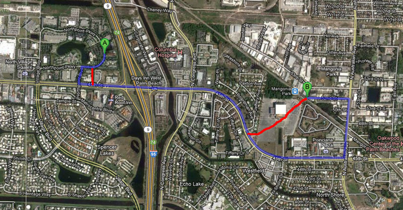
For example, take a look at this route from my crappy hotel in the office park to the commuter rail station a bit over a mile away, given to me via Google maps:

[The sidewalk route I was supposed to have walked.]
Despite the fact that the train station is relatively close, the 'on foot' route is 2.5 miles long due to all the freeways and curving inaccessible roads. (Given that the commonly cited distance for how far people are willing to walk is a scant .5 miles, the station is prohibitively out of reach.)

Except that, if you actually walk this route there are a bunch of 'desire path' possibilities for cutting time off your journey. You can cut through the parking lot, cut through the hedge behind the gas station, and (most importantly) cut through the huge parking lot at the abandoned Jai-Alai “fronton,” which cuts at least a half mile off your trip. (Fronton, by the way, is the Basque word that means "abandoned 500,000 sq ft building.")

[The 'desire' route I actually walked.]
This kind of landscape means that anyone with a head on their shoulders and feet on their legs improvises and short-cuts through the acres of wasted space that pepper the South Florida landscape. There are desire paths everywhere, stretching through the wide lawns, padding down the thick tropical grass, finding crannies in every fenced-off building cluster, winding through the empty lots of undeveloped half-built sheds, wandering through the acres of parking. I did all of those things on my wanderings as a matter of course. It became almost a secret game. Could I figure out a secret path to that would cut my walk in half? Which hedgerow had a secret door that would deliver me to the next impassible road? If I hypotenuse through this parking lot, could I get through the fence on the other side? I cut through this abandoned-looking building, will I get shot for trespassing?

[Your typical South Florida pedestrian, cutting through back yards.]
[Desire path to a parking lot.]
[Desire path through a gas station backyard & office park hedge.]
[The best shortcuts are through empty parking lots.]


[Half-built developments also make for good shortcuts.]
[Desire path by gas station.]

[Security guards watching feral cats at the transit station.]
Variations on this last question kept popping up in my head as I played the improvisational game of ‘walking in Florida.’ I bought some Skittles to keep me going, and kept thinking about the Trayvon Martin tragedy, and how different my experience likely might have been if I was a young black male. (Instead, I was in my Florida tourist outfit: khaki shorts, Velcro sneakers, and the most pastel cruise ship shirt I could find in my closet.) Others have already pointed out how bad urban design was partly responsible for the incident, that a pedestrian in Florida is an aberration who does not belong. Designing your streets only for autos turns pedestrians, bus riders, and the elderly into criminals, obstacles, or pinatas. Urban design is always political.


[The abandoned Palm Beach Jai-Alai fronton.]

[Slow old man crosses the street while someone in a Ferarri revs their V-12.]
[The lovely covered sidewalks of Clematis Street.]
[Nightlife along Clematis Street.]
Of course, not all of South Florida makes you feel like cursed hybrid of the frog in Frogger, the duck in Duck Hunt, and wandering aimlessly in Zelda. That’s only 94% of the landscape; the other 6% is quite nice. For example, Palm Beach and West Palm Beach (they’re different) each have a few blocks  of old downtown with lovely sidewalks, awnings and balconies, and some small businesses in mixed-use environments. West Palm Beach even has three blocks of night life, where seemingly all the bars in the entire city are clustered in a tiny little dollop of town along Clematis Street. Each of these towns (and they are different) has an arcade-style shopping area where you can stroll along a cool canopied sidewalk and window shop, or sit on a bench in the shade and watch impossible clouds go by. West Palm Beach even has small districts of more walkable older homes, with porches and sidewalks. (Palm Beach, on the other hand, is for the wealthy. All the homes are magnificent, huge, and covered by porches and decks. Also, they're all protected by walls. Yeah, they're different in the same way that Old Navy and J. Crew are different.) Even in Florida, there are tiny islands of urban space, remnants of the early 20th century that predate our air conditioned escape from reality.


[CityPlace, the covered mixed-use shopping development in West Palm Beach.]
[CityPlace plaza at midday.]


["The Vias," a gorgeous expensive Italian-esque shopping district in Palm Beach.]
[Fancy Palm Beach house.]
[Fancy pink Palm Beach house.]
[A picture of old West Palm, with bicycles and porticoes.]

But its precisely these urban tidbits that throw a spotlight on the inequality of the urban fabric. These pleasant patches only prove the problems of the rest of the landscape, how impossibly restricted and  undignified the alternatives. The landscape seems to me a fractured confusion of compounds missing continuity. Measure or connection between places has been replaced by independent disjointed bubbles, each sufficient to itself, forming some complex system the logic of which escapes me. There is the Florida of the coasts and the red Italian sports cars, fortifications of power and money connected by airplanes, freeways, and yachts. There is the spectacle Florida, manufactured and reflected around the hemisphere, a polished portrait hawked as a poultice, place-experience sold like a smooth cruise. There’s the faded Florida of the aging, with cheap fancy houses and golf carts and chrome Cadillacs. And in between all these complex networks stretched across the landscape, you’ll find a regular place, a city of people trying to get to work or go to school, having to make their way across an extreme landscape.

[An armadillo on an onramp.]
And you can tell that Florida is beautiful underneath the concrete. You can feel the old compelling land of swamps and sargasso just underneath the surface. You find an armadillo on an on-ramp or a snail crawling cross an ashtray and you realize that you're not actually trapped in a postcard, that there's a volatile world squirming in the grasp of Modernist fantasia. If you walk far enough you’ll find the ocean, a sublime sight that not even our collective American hallucination can mangle.** Florida's ocean is the great equalizer. Everyone is insignificant beside the infinite Atlantic. The beach greets everyone with the same unintelligible hypnotism and a seashell between your toes, its power so much more than anything mastered or mustered. It threatens and beckons and murmurs. The ocean makes the walk seem almost worth it.

[Surs les pavés, la plage.]


* Nobody says this.
** Not actually true. Trawlers are actually quite efficient at destroying entire oceanic ecosystems. But still, the ocean looks amazing.